IMAGES TAKEN NEAR TO
Reservoir Road, EBBW VALE, NP23 5DE
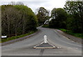
Introduction
This page details the photographs taken nearby to Reservoir Road, NP23 5DE by members of the Geograph project.
The Geograph project started in 2005 with the aim of publishing, organising and preserving representative images for every square kilometre of Great Britain, Ireland and the Isle of Man.

There are currently over 7.5m images from over14,400 individuals and you can help contribute to the project by visiting https://www.geograph.org.uk
Image Map
Images are licensed for reuse under creativecommons.org/licenses/by-sa/2.0
Notes
- Clicking on the map will re-center to the selected point.
- The higher the marker number, the further away the image location is from the centre of the postcode.
Image Listing (38 Images Found)
Images are licensed for reuse under creativecommons.org/licenses/by-sa/2.0
Image
Details
Distance
1
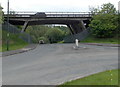
A465 bridge over Reservoir Road, Carmeltown
The bridge carries the A465 Heads of the Valley Road.
Image: © Jaggery
Taken: 16 May 2014
0.04 miles
2
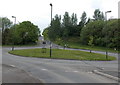
Lampposts on a roundabout near Rassau
Viewed from Prince Philip Avenue. The cars are passing the Rassau boundary sign http://www.geograph.org.uk/photo/3992062 alongside Honeyfield Road.
Image: © Jaggery
Taken: 16 May 2014
0.05 miles
3
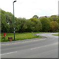
Honeyfield Road postbox, Rassau
Located near the eastern end of Honeyfield Road, near the Rassau boundary sign. http://www.geograph.org.uk/photo/3992062
Next to the box is a brick cube which appears to have been a base for something now removed.
Image: © Jaggery
Taken: 16 May 2014
0.06 miles
4
Honeyfield Road passes the Rassau boundary sign
Rassau is a small village in the north of the county borough of Blaenau Gwent, near the Powys border.
Image: © Jaggery
Taken: 16 May 2014
0.06 miles
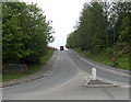
5
Western end of Prince Philip Avenue near Garnlydan
Viewed from this http://www.geograph.org.uk/photo/3992070 roundabout. The Garnlydan boundary sign http://www.geograph.org.uk/photo/3991997 is out of shot ahead.
Image: © Jaggery
Taken: 16 May 2014
0.07 miles
6
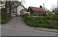
Carn Ifor farm, Garnlydan
Viewed across Prince Philip Avenue.
Image: © Jaggery
Taken: 16 May 2014
0.10 miles
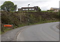
7
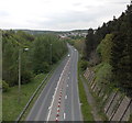
End of a coned-off section of the A465, Garnlydan
Viewed from this http://www.geograph.org.uk/photo/3991559 footbridge. The long line of red and white cones blocking off the middle lane of the Heads of the Valleys Road behind the camera http://www.geograph.org.uk/photo/3991561 ends in the middle distance.
Image: © Jaggery
Taken: 16 May 2014
0.11 miles
8
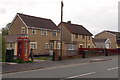
Phonebox and telecoms cabinet, Honeyfield Road, Rassau
Viewed from the corner of Rowan Way. http://www.geograph.org.uk/photo/3992346
Image: © Jaggery
Taken: 16 May 2014
0.12 miles
9
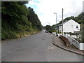
Reservoir Road, Ebbw Vale
Looking north from the corner of Greenfield Crescent.
Image: © Jaggery
Taken: 10 Sep 2013
0.13 miles
10
Garnlydan boundary sign
Alongside Prince Philip Avenue opposite a tight bend. The white cross on the hillside building
is on the wall of Garnlydan Presbyterian Church of Wales. http://www.geograph.org.uk/photo/3991670
Image: © Jaggery
Taken: 16 May 2014
0.13 miles