IMAGES TAKEN NEAR TO
Station Approach, EBBW VALE, NP23 5AY
Introduction
This page details the photographs taken nearby to Station Approach, NP23 5AY by members of the Geograph project.
The Geograph project started in 2005 with the aim of publishing, organising and preserving representative images for every square kilometre of Great Britain, Ireland and the Isle of Man.

There are currently over 7.5m images from over14,400 individuals and you can help contribute to the project by visiting https://www.geograph.org.uk
Image Map
Images are licensed for reuse under creativecommons.org/licenses/by-sa/2.0
Notes
- Clicking on the map will re-center to the selected point.
- The higher the marker number, the further away the image location is from the centre of the postcode.
Image Listing (159 Images Found)
Images are licensed for reuse under creativecommons.org/licenses/by-sa/2.0
Image
Details
Distance
1
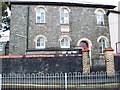
Ebenezer Chapel, Ebbw Vale
Ebenezer Chapel situated in Pont-y-Gôf, Ebbw Vale. It is in the process of being renovated.
Image: © bracaragh
Taken: 21 Mar 2008
0.00 miles
2
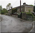
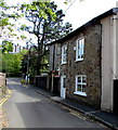
Station Cottages, Station Approach, Pontygof, Ebbw Vale
Viewed in September 2017. The name of the cottages and street is a relic of a long-closed railway station.
Image: © Jaggery
Taken: 10 Sep 2017
0.01 miles
3
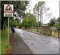
Warning sign - School, Station Approach, Pontygof, Ebbw Vale
In September 2017, the monolingual sign has not yet been replaced
by the School/Ysgol or Ysgol/School sign usually seen in Wales.
Image: © Jaggery
Taken: 10 Sep 2017
0.01 miles
4
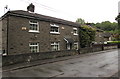
Station Cottages, Station Approach, Pontygof, Ebbw Vale
Viewed in September 2017. The name of the cottages and street is a relic of a long-closed railway station.
Image: © Jaggery
Taken: 10 Sep 2017
0.01 miles
5
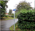
National Cycle Network Route 466 direction sign, Station Approach, Pontygof, Ebbw Vale
Viewed in September 2017. When complete, National Cycle Network Route 466 will connect the Heads of the Valleys with Pontypool.
Image: © Jaggery
Taken: 10 Sep 2017
0.02 miles
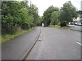
6
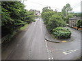
Ebbw Vale Low Level railway station (site), Blaenau Gwent
Opened in 1859 by the Monmouthshire Railway & Canal Company, later part of the Great Western Railway, as the terminus of the line from Newport (Gwent), this station replaced an earlier 1852 terminus some 600m south of here. In turn, this station closed in 1962. The line was later turned into a road. The single platform ran roughly along the right hand carriageway of the road and the main building was where the trees to the right of the road now are.
View north towards the buffers. Although this was the end of the line for passengers, freight trains ran a little further north.
Image: © Nigel Thompson
Taken: 14 Aug 2015
0.02 miles
7
Vestry House, Pontygof, Ebbw Vale
Located next door to Ebbw Vale Christian Spiritualist Church. http://www.geograph.org.uk/photo/4495228 The church is in the former Ebenezer chapel, which suggests that Vestry House was originally the building used for keeping Ebenezer's vestments, vessels, records, etc, and as a robing-room.
Image: © Jaggery
Taken: 27 May 2015
0.03 miles
8
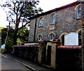
Ebbw Vale Christian Spiritualist Church
Located in the former Ebenezer chapel in Pont-y-gof. The years 1850 and 1911 on the tablet
on the wall probably indicate that this is the 1911 rebuild of the original 1850 chapel.
Image: © Jaggery
Taken: 27 May 2015
0.03 miles
9
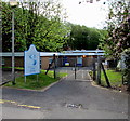
The River Centre (Canolfan yr Afon), Ebbw Vale
Blaenau Gwent County Borough Council Pupil Referral Unit located in the former Pontygof Primary School site. Pontygof closed down after its pupils transferred to the new Ebbw Fawr Learning Community, the first 3-16 maintained school in Wales.
Image: © Jaggery
Taken: 27 May 2015
0.04 miles
10
Ebbw Vale Low Level railway station (site), Blaenau Gwent
Opened in 1859 by the Monmouthshire Railway & Canal Company, later part of the Great Western Railway, as the terminus of the line from Newport (Gwent), this station replaced an earlier 1852 terminus some 600m south of here. In turn, this station closed in 1962. The line was later turned into a road and raised slightly. The single platform ran roughly along the left hand carriageway of the road and the main building was where the trees to the left now are.
View south towards the current Ebbw Vale Town station, beyond the tunnel, and Newport, Cardiff etc.
Image: © Nigel Thompson
Taken: 14 Aug 2015
0.04 miles