IMAGES TAKEN NEAR TO
Attlee Road, EBBW VALE, NP23 4WA
Introduction
This page details the photographs taken nearby to Attlee Road, NP23 4WA by members of the Geograph project.
The Geograph project started in 2005 with the aim of publishing, organising and preserving representative images for every square kilometre of Great Britain, Ireland and the Isle of Man.

There are currently over 7.5m images from over14,400 individuals and you can help contribute to the project by visiting https://www.geograph.org.uk
Image Map
Images are licensed for reuse under creativecommons.org/licenses/by-sa/2.0
Notes
- Clicking on the map will re-center to the selected point.
- The higher the marker number, the further away the image location is from the centre of the postcode.
Image Listing (15 Images Found)
Images are licensed for reuse under creativecommons.org/licenses/by-sa/2.0
Image
Details
Distance
1
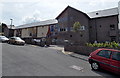
Recently-built care home in Hospital Road, Nantyglo
Managed by United Welsh Housing Association, Llys Nant y Mynydd was built in 2011. It is extra care housing, containing 44 1-bedroom or 2-bedroom flats. The extra care scheme includes on-site care staff, non-resident management staff and a community alarm service.
Image: © Jaggery
Taken: 26 Jul 2013
0.15 miles
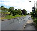
2
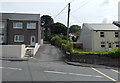
Road to Lower Coedcae, Nantyglo
Viewed across Queen Street. A sign on the right corner points towards Lower Coedcae.
Image: © Jaggery
Taken: 26 Jul 2013
0.16 miles
3
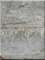
Ordnance Survey Rivet
This OS rivet can be found on the old Public House on Queen Street. It marks a point 353.684m above mean sea level.
Image: © Adrian Dust
Taken: 30 Jun 2023
0.17 miles
4
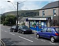
B&S Stores, Nantyglo
Shop and off licence in Queen Street.
Image: © Jaggery
Taken: 26 Jul 2013
0.17 miles
5
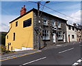
The Golden Lion, Nantyglo
Pub with bed & breakfast accommodation located in Queen Street, Nantyglo
Image: © Jaggery
Taken: 26 Jul 2013
0.18 miles
6
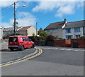
Royal Mail van in Nantyglo
Parked at the edge of Queen Street.
Is the red and white chequered pattern a Royal Mail version of go faster stripes?
Image: © Jaggery
Taken: 18 Sep 2013
0.18 miles
7
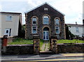
Former Ebenezer Primitive Methodist Chapel, Nantyglo
Located between 72 and 73 Queen Street, now a private residence.
The chapel name inscription on the wall shows the year 1883.
Image: © Jaggery
Taken: 26 Jul 2013
0.18 miles
9
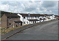
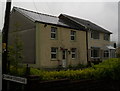
Dale View houses, Nantyglo
On the west side of Queen Street, viewed from the lane to Coalbrookvale.
Image: © Jaggery
Taken: 26 Jul 2013
0.21 miles
10
Gwent Terrace SE of Ffosmaen Road, Nantyglo
Looking towards Cae Glas and Coedcae.
Image: © Jaggery
Taken: 14 Jun 2013
0.21 miles