IMAGES TAKEN NEAR TO
Aneurin Place, EBBW VALE, NP23 4RU
Introduction
This page details the photographs taken nearby to Aneurin Place, NP23 4RU by members of the Geograph project.
The Geograph project started in 2005 with the aim of publishing, organising and preserving representative images for every square kilometre of Great Britain, Ireland and the Isle of Man.

There are currently over 7.5m images from over14,400 individuals and you can help contribute to the project by visiting https://www.geograph.org.uk
Image Map
Images are licensed for reuse under creativecommons.org/licenses/by-sa/2.0
Notes
- Clicking on the map will re-center to the selected point.
- The higher the marker number, the further away the image location is from the centre of the postcode.
Image Listing (102 Images Found)
Images are licensed for reuse under creativecommons.org/licenses/by-sa/2.0
Image
Details
Distance
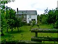
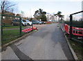
1
Aneurin Place, Brynmawr
Viewed from Aneurin Crescent in the north of Brynmawr.
Image: © Jaggery
Taken: 2 Feb 2016
0.05 miles
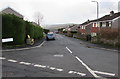
2
Houses and hedge, Aneurin Crescent, Brynmawr
Aneurin Crescent northeast of the Aneurin Place junction, viewed looking towards the northeast edge of residential Brynmawr.
Image: © Jaggery
Taken: 2 Feb 2016
0.06 miles
3
Brynmawr Foundation School
Comprehensive school viewed from the entrance drive from Intermediate Road.
Image: © Jaggery
Taken: 2 Feb 2016
0.07 miles
4
Brynmawr Foundation School entrance drive
From Intermediate Road, Brynmawr
Image: © Jaggery
Taken: 2 Feb 2016
0.09 miles
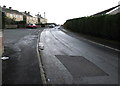
5
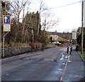
Intermediate Road speed bumps, Brynmawr
The speed bumps and Priority over oncoming vehicles sign are near a school entrance behind the camera.
Image: © Jaggery
Taken: 2 Feb 2016
0.10 miles
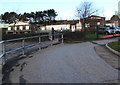
6
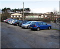
Parking area on the west side of Intermediate Road, Brynmawr
At the edge of Brynmawr Foundation School.
Image: © Jaggery
Taken: 2 Feb 2016
0.10 miles
7
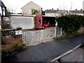
Not a public phonebox, Brynmawr
In a yard on the north side of Aneurin Crescent, a former phonebox is being used for storage in February 2016.
Image: © Jaggery
Taken: 2 Feb 2016
0.10 miles
8
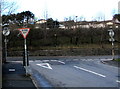
Junction of King Edward Road and Intermediate Road, Brynmawr
A Give Way sign faces King Edward Road at the Intermediate Road junction.
Image: © Jaggery
Taken: 2 Feb 2016
0.11 miles
9
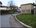
Intermediate Road electricity substation, Brynmawr
The Western Power Distribution electricity substation is alongside
the entrance drive from Intermediate Road to Brynmawr Foundation School.
Image: © Jaggery
Taken: 2 Feb 2016
0.11 miles