IMAGES TAKEN NEAR TO
Pleasant View, EBBW VALE, NP23 4RP
Introduction
This page details the photographs taken nearby to Pleasant View, NP23 4RP by members of the Geograph project.
The Geograph project started in 2005 with the aim of publishing, organising and preserving representative images for every square kilometre of Great Britain, Ireland and the Isle of Man.

There are currently over 7.5m images from over14,400 individuals and you can help contribute to the project by visiting https://www.geograph.org.uk
Image Map
Images are licensed for reuse under creativecommons.org/licenses/by-sa/2.0
Notes
- Clicking on the map will re-center to the selected point.
- The higher the marker number, the further away the image location is from the centre of the postcode.
Image Listing (92 Images Found)
Images are licensed for reuse under creativecommons.org/licenses/by-sa/2.0
Image
Details
Distance
1
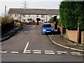
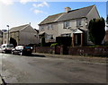
Pleasant View, Brynmawr
Pleasant View is a cul-de-sac on the west side of Clydach Street.
Image: © Jaggery
Taken: 2 Feb 2016
0.02 miles
2
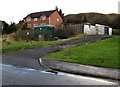
Electricity substation, house and lockup garages in the north of Brynmawr
Viewed across Clydach Street.
Image: © Jaggery
Taken: 2 Feb 2016
0.03 miles
3
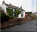
Ivy-clad house, Clydach Street, Brynmawr
House in the north of Brynmawr. The street here is 380 metres (c1,250 ft) above mean sea level.
Image: © Jaggery
Taken: 2 Feb 2016
0.03 miles
4
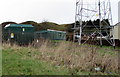
Clydach Street electricity substation , Brynmawr
The dark green cabinet inside an enclosure on the left is a Western Power Distribution electricity substation, identifier CLYDACH ST BRYNMAWR S/S 553212. The base of an electricity pylon http://www.geograph.org.uk/photo/4833843 is on the right.
Image: © Jaggery
Taken: 2 Feb 2016
0.04 miles
5
West side of Clydach Street, Brynmawr
The semi-detached houses on the right are near the corner of Pleasant View. http://www.geograph.org.uk/photo/4833838
Image: © Jaggery
Taken: 2 Feb 2016
0.04 miles
6
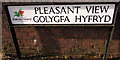
Bilingual street name sign, Pleasant View/Golygfa Hyfryd, Brynmawr
The Blaenau Gwent County Borough Council sign is on the corner of Clydach Street and Pleasant View. http://www.geograph.org.uk/photo/4833838
Image: © Jaggery
Taken: 2 Feb 2016
0.04 miles
7
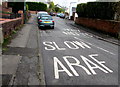
ARAF/SLOW on Clydach Street, Brynmawr
Bilingual (Welsh/English) instruction to drivers, painted on Clydach Street.
Image: © Jaggery
Taken: 2 Feb 2016
0.04 miles
8
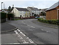
Bend in Clydach Street, Brynmawr
Viewed from the corner of the street named Brynawel.
Image: © Jaggery
Taken: 2 Feb 2016
0.04 miles
9
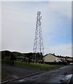
Electricity pylon in the north of Brynmawr
Towering above the west side of Clydach Street.
Image: © Jaggery
Taken: 2 Feb 2016
0.05 miles
10
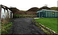
Lockup garages and mounds in the north of Brynmawr
On the west side of Clydach Street.
Maps show that the mounds are at the eastern edge of former industrial workings and tips.
Image: © Jaggery
Taken: 2 Feb 2016
0.05 miles