1
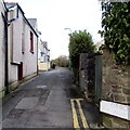
Church Lane, Brynmawr
From King Street towards the church of St Mary the Virgin.
Image: © Jaggery
Taken: 2 Feb 2016
0.01 miles
2
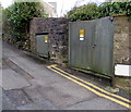
Electricity substation on a Brynmawr corner
The Western Power Distribution electricity substation is at the southern end of Church Lane,
on the corner of King Street. Its identifier is KING ST BRYNMAWR S/S 553221.
Image: © Jaggery
Taken: 2 Feb 2016
0.01 miles
3
Plasgeller Brynmawr
Care home on the west side of Intermediate Road in Brynmawr.
Image: © Jaggery
Taken: 2 Feb 2016
0.02 miles
4
Southern end of Intermediate Road, Brynmawr
The 20mph speed limit on Intermediate Road increases to 30mph at the A4047 King Street junction.
Image: © Jaggery
Taken: 2 Feb 2016
0.02 miles
5
The Bush, Brynmawr
Pub on the corner of Bailey Street and King Street.
Image: © Jaggery
Taken: 2 Feb 2016
0.04 miles
6
King Street side of The Bush, Brynmawr
The north side of the pub http://www.geograph.org.uk/photo/4826747 on the corner of Bailey Street.
Image: © Jaggery
Taken: 2 Feb 2016
0.04 miles
7
St. Mary's Church, Brynmawr
The building of St. Mary's Church in Brynmawr was completed in 1900.
Image: © Trevor Littlewood
Taken: 5 Mar 2008
0.04 miles
8
North side of the Church of St Mary the Virgin, Brynmawr
Viewed from the churchyard path, this is the 1899-1900 rebuild of the 1872 original.
The church is part of the Diocese of Swansea & Brecon, one of the six Dioceses of the Church in Wales.
Image: © Jaggery
Taken: 2 Feb 2016
0.04 miles
9
Ordnance Survey Flush Bracket (S1194)
This OS Flush Bracket can be found on the NE angle of St Mary's Church. It marks a point 363.087m above mean sea level.
Image: © Adrian Dust
Taken: 4 Oct 2018
0.04 miles
10
Church of St Mary the Virgin, Brynmawr
Located on the north side of Dumfries Place and Church Lane, the church is part of
the Diocese of Swansea & Brecon, one of the six Dioceses of the Church in Wales.
The church is the 1899-1900 rebuild of the 1872 original.
Image: © Jaggery
Taken: 2 Feb 2016
0.04 miles


