IMAGES TAKEN NEAR TO
Nantyglo Caravan Site, EBBW VALE, NP23 4NT
Introduction
This page details the photographs taken nearby to Nantyglo Caravan Site, NP23 4NT by members of the Geograph project.
The Geograph project started in 2005 with the aim of publishing, organising and preserving representative images for every square kilometre of Great Britain, Ireland and the Isle of Man.

There are currently over 7.5m images from over14,400 individuals and you can help contribute to the project by visiting https://www.geograph.org.uk
Image Map
Images are licensed for reuse under creativecommons.org/licenses/by-sa/2.0
Notes
- Clicking on the map will re-center to the selected point.
- The higher the marker number, the further away the image location is from the centre of the postcode.
Image Listing (21 Images Found)
Images are licensed for reuse under creativecommons.org/licenses/by-sa/2.0
Image
Details
Distance
1
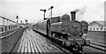
Brynmawr station, with local train from Newport.
View westward, towards Merthyr on the ex-LNW Abergavenny - Merthyr line (closed 1/58), from which branched left (southward) the line to Newport (ex-GW & LNW Joint as far as Nantyglo, then GWR). Brynmawr station was closed on 30/4/62 when the Newport service ceased. See also Image The locomotive is '8750' class 0-6-0PT No. 8796 (built 3/34, withdrawn 4/61).
Image: © Ben Brooksbank
Taken: 11 May 1957
0.05 miles
2
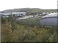
Barley Fields Industrial Estate, Brynmawr
Image: © Kev Griffin
Taken: 16 Nov 2004
0.05 miles

4
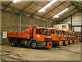
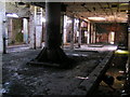
Off duty gritters
Inside the workshops of the council depot on Barleyfields industrial estate
Image: © andy dolman
Taken: 12 Mar 2008
0.17 miles
8
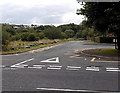
Access road to Blaenycwm County Primary School, Brynmawr
Viewed across the B4248. A large purpose-built school which opened in 1991,
Blaenycwm serves the communities of Brynmawr and Nantyglo.
Image: © Jaggery
Taken: 14 Sep 2013
0.23 miles
10
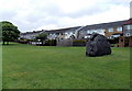
Large boulder on a green alongside Chapel Road, Nantyglo
Is the boulder a natural feature or has it been placed here at the side of Chapel Road? There is no plaque on the boulder. Nearby is Limestone Road, which suggests a former quarrying area...
Image: © Jaggery
Taken: 14 Jun 2013
0.24 miles