IMAGES TAKEN NEAR TO
Park View, EBBW VALE, NP23 4HP
Introduction
This page details the photographs taken nearby to Park View, NP23 4HP by members of the Geograph project.
The Geograph project started in 2005 with the aim of publishing, organising and preserving representative images for every square kilometre of Great Britain, Ireland and the Isle of Man.

There are currently over 7.5m images from over14,400 individuals and you can help contribute to the project by visiting https://www.geograph.org.uk
Image Map
Images are licensed for reuse under creativecommons.org/licenses/by-sa/2.0
Notes
- Clicking on the map will re-center to the selected point.
- The higher the marker number, the further away the image location is from the centre of the postcode.
Image Listing (43 Images Found)
Images are licensed for reuse under creativecommons.org/licenses/by-sa/2.0
Image
Details
Distance
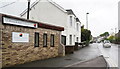
2
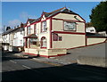
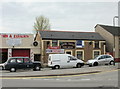
Gold Diggers Arms, Brynmawr
Pub, with its own car park, at 122 King Street.
Image: © Jaggery
Taken: 20 Oct 2010
0.11 miles
3
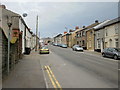
George Street, Brynmawr
George Street climbs away from Bailey Street towards King Street.
Image: © Jaggery
Taken: 28 Apr 2010
0.11 miles
4
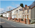
King Street houses, Brynmawr
Houses on the north side of King Street, between Hill Street and George Street.
Image: © Jaggery
Taken: 20 Oct 2010
0.11 miles
5
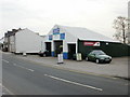
Merthyr Road Garage, Brynmawr
Despite its name, the garage is located on King Street, on the corner of Bath Lane.
Image: © Jaggery
Taken: 28 Apr 2010
0.12 miles
7
King David, Brynmawr
Pub at 61 Bailey Street. Its status as at late April 2010 is unclear : the windows are not boarded up, but there is an 'All enquiries' board affixed to the premises.
Image: © Jaggery
Taken: 28 Apr 2010
0.12 miles
8
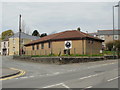
St John Ambulance, Brynmawr
Located on the corner of Worcester Street and George Street, the St. John Ambulance premises occupy the site of the former Tin Church (Mission Church).
Image: © Jaggery
Taken: 28 Apr 2010
0.12 miles
9
Oaklands Funeral Home, King Street, Twyn Cynholdy
Image: © Ian S
Taken: 24 May 2014
0.13 miles
10
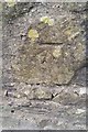
Ordnance Survey Cut Mark
This OS cut mark can be found on the wall south side of King Street. It marks a point 377.248m above mean sea level.
Image: © Adrian Dust
Taken: 4 Oct 2018
0.14 miles