IMAGES TAKEN NEAR TO
Brecnock Close, EBBW VALE, NP23 4FB
Introduction
This page details the photographs taken nearby to Brecnock Close, NP23 4FB by members of the Geograph project.
The Geograph project started in 2005 with the aim of publishing, organising and preserving representative images for every square kilometre of Great Britain, Ireland and the Isle of Man.

There are currently over 7.5m images from over14,400 individuals and you can help contribute to the project by visiting https://www.geograph.org.uk
Image Map
Images are licensed for reuse under creativecommons.org/licenses/by-sa/2.0
Notes
- Clicking on the map will re-center to the selected point.
- The higher the marker number, the further away the image location is from the centre of the postcode.
Image Listing (316 Images Found)
Images are licensed for reuse under creativecommons.org/licenses/by-sa/2.0
Image
Details
Distance
2
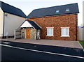
1st Brynmawr Scout Group hall, Brynmawr
Located in recently-built premises at the eastern end of Brecknock Walk,
near the corner of Greenland Road. Viewed in early February 2016.
Image: © Jaggery
Taken: 2 Feb 2016
0.04 miles
3
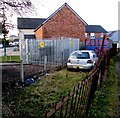
Greenland Road electricity substation, Brynmawr
The Western Power Distribution electricity substation is in an enclosure set back from the west side of Greenland Road. Its identifier is GREENLAND RD BRYNMAWR S/S 553182.
Image: © Jaggery
Taken: 2 Feb 2016
0.04 miles
4
Birds on a wire artwork, Brynmawr
One of several items of public art along Alma Street, the work of Brighton-based artist Jon Mills who specialises in working with steel. The project was funded by the Arts Council of Wales, the Welsh Assembly Government and Blaenau Gwent County Borough Council.
Image: © Jaggery
Taken: 7 Jun 2013
0.04 miles
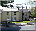
7
North along Greenland Road, Brynmawr
Viewed from near the Hobby Horse Inn. http://www.geograph.org.uk/photo/4819438
Image: © Jaggery
Taken: 2 Feb 2016
0.05 miles
8
South along Greenland Road, Brynmawr
Central part of a road extending for 350 metres from Alma Street behind the camera to Factory Road ahead.
Image: © Jaggery
Taken: 2 Feb 2016
0.05 miles
9
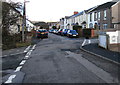
Minor crossroads in Brynmawr
Looking north along Greenland Road past the Brecknock Walk
junction on the left and the Old Blaen-Afon Road junction on the right.
Image: © Jaggery
Taken: 2 Feb 2016
0.05 miles
10
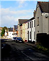
Factory Road, Brynmawr
Looking NNW from the corner of Clarence Street.
Image: © Jaggery
Taken: 2 Feb 2016
0.05 miles