IMAGES TAKEN NEAR TO
Catholic Road, EBBW VALE, NP23 4EF
Introduction
This page details the photographs taken nearby to Catholic Road, NP23 4EF by members of the Geograph project.
The Geograph project started in 2005 with the aim of publishing, organising and preserving representative images for every square kilometre of Great Britain, Ireland and the Isle of Man.

There are currently over 7.5m images from over14,400 individuals and you can help contribute to the project by visiting https://www.geograph.org.uk
Image Map
Images are licensed for reuse under creativecommons.org/licenses/by-sa/2.0
Notes
- Clicking on the map will re-center to the selected point.
- The higher the marker number, the further away the image location is from the centre of the postcode.
Image Listing (258 Images Found)
Images are licensed for reuse under creativecommons.org/licenses/by-sa/2.0
Image
Details
Distance
1
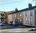
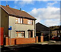
Clarence Street houses, Brynmawr
Houses on the south side of Clarence Street, between Curzon Street and Factory Road.
Image: © Jaggery
Taken: 20 Oct 2010
0.02 miles
2
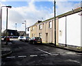
Curzon Street, Brynmawr
Short street extending from Clarence Street (on this side) to Catholic Road.
Image: © Jaggery
Taken: 2 Feb 2016
0.03 miles
3
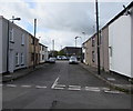
Curzon Street, Brynmawr
From Clarence Street along Curzon Street towards Catholic Road.
Image: © Jaggery
Taken: 18 Aug 2017
0.03 miles
4
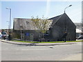
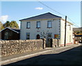
St Mary's church, Catholic Road, Brynmawr
Roman Catholic church located on Catholic Road.
Image: © Jaggery
Taken: 21 Apr 2010
0.04 miles
5
Zion Baptist Church, Brynmawr
Located on Clarence Street, between Gladstone Street and Curzon Street. The church hall is on the left.
Image: © Jaggery
Taken: 20 Oct 2010
0.04 miles
6
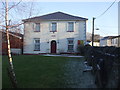
Catholic School, Catholic Road, Brynmawr
St Mary's Roman Catholic Nursery, Infant and Junior School located on Catholic Road, alongside St Mary's church. http://www.geograph.org.uk/photo/1820597
Image: © Jaggery
Taken: 29 Mar 2011
0.04 miles
7
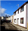
Sunny side of Clarence Street, Brynmawr
South-facing houses in sunshine a few minutes after noon in early February 2016.
Image: © Jaggery
Taken: 2 Feb 2016
0.04 miles
9
Welsh Water notice, Clarence Street, Brynmawr
Below a National Cycle Network route 46 sign on the pole on the left, a Welsh Water notice states
"Clarence Street. Reducing sewer flooding and helping to protect your environment for years to come"
Image: © Jaggery
Taken: 2 Feb 2016
0.04 miles
10
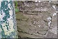
Ordnance Survey Cut Mark
This OS cut mark can be found on the wall south side of Clarence Street. It marks a point 347.978m above mean sea level.
Image: © Adrian Dust
Taken: 4 Oct 2018
0.05 miles