IMAGES TAKEN NEAR TO
Greenland Road, EBBW VALE, NP23 4DT
Introduction
This page details the photographs taken nearby to Greenland Road, NP23 4DT by members of the Geograph project.
The Geograph project started in 2005 with the aim of publishing, organising and preserving representative images for every square kilometre of Great Britain, Ireland and the Isle of Man.

There are currently over 7.5m images from over14,400 individuals and you can help contribute to the project by visiting https://www.geograph.org.uk
Image Map
Images are licensed for reuse under creativecommons.org/licenses/by-sa/2.0
Notes
- Clicking on the map will re-center to the selected point.
- The higher the marker number, the further away the image location is from the centre of the postcode.
Image Listing (254 Images Found)
Images are licensed for reuse under creativecommons.org/licenses/by-sa/2.0
Image
Details
Distance
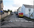
1
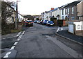
Minor crossroads in Brynmawr
Looking north along Greenland Road past the Brecknock Walk
junction on the left and the Old Blaen-Afon Road junction on the right.
Image: © Jaggery
Taken: 2 Feb 2016
0.01 miles
2
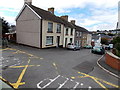
Western side of Old Blaenavon Road, Brynmawr
Viewed from the edge of this http://www.geograph.org.uk/photo/3736070 footbridge across the A467. The bridge connects the two sides of Old Blaenavon Road.
Image: © Jaggery
Taken: 14 Sep 2013
0.01 miles
3
North along Greenland Road, Brynmawr
Viewed from near the Hobby Horse Inn. http://www.geograph.org.uk/photo/4819438
Image: © Jaggery
Taken: 2 Feb 2016
0.02 miles
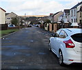
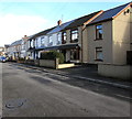
4
South along Greenland Road, Brynmawr
Central part of a road extending for 350 metres from Alma Street behind the camera to Factory Road ahead.
Image: © Jaggery
Taken: 2 Feb 2016
0.02 miles
5
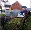
Greenland Road electricity substation, Brynmawr
The Western Power Distribution electricity substation is in an enclosure set back from the west side of Greenland Road. Its identifier is GREENLAND RD BRYNMAWR S/S 553182.
Image: © Jaggery
Taken: 2 Feb 2016
0.02 miles
6
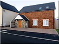
1st Brynmawr Scout Group hall, Brynmawr
Located in recently-built premises at the eastern end of Brecknock Walk,
near the corner of Greenland Road. Viewed in early February 2016.
Image: © Jaggery
Taken: 2 Feb 2016
0.03 miles
7
Old Blaen-Afon Road towards Gordon Terrace, Brynmawr
Viewed across Greenland Road looking past a Royal Mail van.
Image: © Jaggery
Taken: 2 Feb 2016
0.03 miles
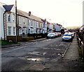
8
Long row of houses, Greenland Road, Brynmawr
Extending for 50 metres on the east side of Greenland Road, north of the Old Blaen-Afon Road junction.
Image: © Jaggery
Taken: 2 Feb 2016
0.03 miles
9
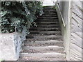
Steps up from the A467, Brynmawr
Ascending to Old Blaen-Afon Road from the west side of the A467.
Image: © Jaggery
Taken: 18 Aug 2017
0.03 miles
10
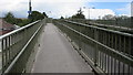
Footbridge access ramp, Brynmawr
From Old Blaen-Afon Road to this http://www.geograph.org.uk/photo/5503963 footbridge over the A467.
Image: © Jaggery
Taken: 18 Aug 2017
0.04 miles