IMAGES TAKEN NEAR TO
NP2 2BE
Introduction
This page details the photographs taken nearby to NP2 2BE by members of the Geograph project.
The Geograph project started in 2005 with the aim of publishing, organising and preserving representative images for every square kilometre of Great Britain, Ireland and the Isle of Man.

There are currently over 7.5m images from over14,400 individuals and you can help contribute to the project by visiting https://www.geograph.org.uk
Image Map
Images are licensed for reuse under creativecommons.org/licenses/by-sa/2.0
Notes
- Clicking on the map will re-center to the selected point.
- The higher the marker number, the further away the image location is from the centre of the postcode.
Image Listing (8 Images Found)
Images are licensed for reuse under creativecommons.org/licenses/by-sa/2.0
Image
Details
Distance
1
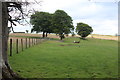
Pasture above Abercarn
Fields at head of valley.
Image: © M J Roscoe
Taken: 20 Jun 2020
0.16 miles
2
Pasture above Abercarn
Only approachable from the west, this rough pasture is part of farmland above Abercarn to the east.
Image: © Graham Horn
Taken: 6 Jan 2008
0.19 miles
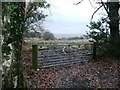
3
Field below Church Farm
Upper part of field above Sychpant Farm.
Image: © M J Roscoe
Taken: 20 Jun 2020
0.19 miles
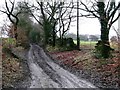
4
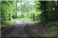
Restricted byway to Penrhiw-darren Farm
The two gates across the road can be operated remotely.
Image: © M J Roscoe
Taken: 20 Jun 2020
0.19 miles
5
Track to Graig Farm
The track heads south further into the square. However, there was a motor cycle scrambling event at the farm and I had to reverse down the lane three times as lots of "white" vans were leaving and they weren't giving way. So here's the northern part of the square.
Image: © Graham Horn
Taken: 6 Jan 2008
0.20 miles
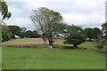
6
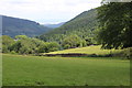
Fields above Sychpant Farm
Looking down the Ebbw Valley and to the Severn.
Image: © M J Roscoe
Taken: 20 Jun 2020
0.20 miles
7
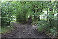
Bridleway on muddy track
Tree-lined bridleway, from byway, to fields.
Image: © M J Roscoe
Taken: 20 Jun 2020
0.22 miles
8
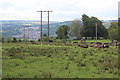
Cows chewing the cud by Ty-mynydd
Cattle under transmission lines in a rushy pasture.
Image: © M J Roscoe
Taken: 20 Jun 2020
0.23 miles