IMAGES TAKEN NEAR TO
The Terrace, TREDEGAR, NP22 5XJ
Introduction
This page details the photographs taken nearby to The Terrace, NP22 5XJ by members of the Geograph project.
The Geograph project started in 2005 with the aim of publishing, organising and preserving representative images for every square kilometre of Great Britain, Ireland and the Isle of Man.

There are currently over 7.5m images from over14,400 individuals and you can help contribute to the project by visiting https://www.geograph.org.uk
Image Map
Images are licensed for reuse under creativecommons.org/licenses/by-sa/2.0
Notes
- Clicking on the map will re-center to the selected point.
- The higher the marker number, the further away the image location is from the centre of the postcode.
Image Listing (285 Images Found)
Images are licensed for reuse under creativecommons.org/licenses/by-sa/2.0
Image
Details
Distance
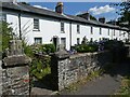
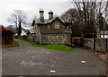
2
The Terrace, Rhymney (2)
19th century company houses.
For another view and details see http://www.geograph.org.uk/photo/2959638 .
Image: © Robin Drayton
Taken: 23 May 2012
0.02 miles
3
The Terrace, Rhymney
Sports courts are on the left. Houses https://www.geograph.org.uk/photo/6000216 are on the right.
Image: © Jaggery
Taken: 12 Dec 2018
0.03 miles
4

Houses on the northeast side of The Terrace, Rhymney
The houses are opposite sports courts.
Image: © Jaggery
Taken: 12 Dec 2018
0.03 miles
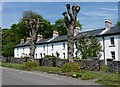
5
The Terrace, Rhymney (1)
19th century company houses.
These houses belonged to the Rhymney Iron Company which in the 1880s was recorded as owning eight hundred houses, shops and a brewery.
Thomas Jones, who moved into one of these houses in 1881 writes in 'Rhymney Memories' (1930):
“The Terrace was a row of superior houses where the managers lived. The houses were graded to correspond to the industrial importance of their occupants. At each end was a large house standing in its own walled-in grounds with trees and garden to match: these were occupied by the manager of the Company Shop and the chief colliery manager. Then next to these came at each end a house of intermediate size, one occupied by the cashier and one by the assistant-general-manager; the rest of the row was filled in with houses half in size of the two intermediaries, for the lesser managers or superior foreman.”
Image: © Robin Drayton
Taken: 23 May 2012
0.03 miles
6

Manest Street Rhymney
Manest Street heads away from High Street.
Image: © Jaggery
Taken: 7 May 2010
0.03 miles
7
Prospect House, Rhymney
Distinctive stone house alongside a path near the southern end of Goshen Street.
Image: © Jaggery
Taken: 12 Dec 2018
0.03 miles
8

Redwood Memorial Hospital, Rhymney
The hospital was named when the National Health Service was inaugurated in 1948. Lewis Redwood and his son Thomas both held the post of Medical Officer of the Rhymney Iron Works.
Image: © Robin Drayton
Taken: 23 May 2012
0.04 miles
9
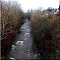
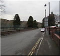
Rhymney River near Rhymney railway station
The Rhymney flows towards the bridge seen here. http://www.geograph.org.uk/photo/3845534
Image: © Jaggery
Taken: 17 Jan 2014
0.04 miles
10
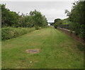
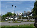
Grassy area near Rhymney railway station
Between the Rhymney River and sports courts.
Image: © Jaggery
Taken: 11 Jul 2019
0.04 miles