IMAGES TAKEN NEAR TO
Bryn-Oer Farm Lane, TREDEGAR, NP22 5QR
Introduction
This page details the photographs taken nearby to Bryn-Oer Farm Lane, NP22 5QR by members of the Geograph project.
The Geograph project started in 2005 with the aim of publishing, organising and preserving representative images for every square kilometre of Great Britain, Ireland and the Isle of Man.

There are currently over 7.5m images from over14,400 individuals and you can help contribute to the project by visiting https://www.geograph.org.uk
Image Map
Images are licensed for reuse under creativecommons.org/licenses/by-sa/2.0
Notes
- Clicking on the map will re-center to the selected point.
- The higher the marker number, the further away the image location is from the centre of the postcode.
Image Listing (2 Images Found)
Images are licensed for reuse under creativecommons.org/licenses/by-sa/2.0
Image
Details
Distance
1
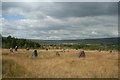
Rhymney Valley Gorsedd Stones
the Gorsedd Stones erected on this site for the 1990 national Eisteddfod
Image: © Eddy Blanche
Taken: 21 Jul 2018
0.16 miles
2
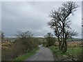
Minor road from Bryn-oer Patch to Rhymney
This road is the route of an old dram road along which mining products were taken beyond the distant hills to the Crawshay's ironworks in Merthyr Tydfil.
For a view a little further along the road see http://www.geograph.org.uk/photo/2932915 .
Image: © Robin Drayton
Taken: 7 Apr 2012
0.24 miles