IMAGES TAKEN NEAR TO
Cwrt Llechryd, TREDEGAR, NP22 5QF
Introduction
This page details the photographs taken nearby to Cwrt Llechryd, NP22 5QF by members of the Geograph project.
The Geograph project started in 2005 with the aim of publishing, organising and preserving representative images for every square kilometre of Great Britain, Ireland and the Isle of Man.

There are currently over 7.5m images from over14,400 individuals and you can help contribute to the project by visiting https://www.geograph.org.uk
Image Map
Images are licensed for reuse under creativecommons.org/licenses/by-sa/2.0
Notes
- Clicking on the map will re-center to the selected point.
- The higher the marker number, the further away the image location is from the centre of the postcode.
Image Listing (56 Images Found)
Images are licensed for reuse under creativecommons.org/licenses/by-sa/2.0
Image
Details
Distance
1
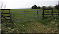
Five-bar field gate, Llechryd
Located a few metres from this https://www.geograph.org.uk/photo/6125711 Llechryd boundary sign.
Image: © Jaggery
Taken: 15 Apr 2019
0.03 miles
2
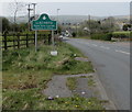
Northern boundary of Llechryd
The road from Princetown reaches Llechryd in Caerphilly County Borough.
Image: © Jaggery
Taken: 15 Apr 2019
0.04 miles
3
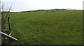
Llechryd grassland
Field viewed from this gate. https://www.geograph.org.uk/photo/6125712
Image: © Jaggery
Taken: 15 Apr 2019
0.05 miles
4
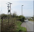
Line spur pole in a Llechryd field
A rural part of the Western Power Distribution electricity supply infrastructure.
Image: © Jaggery
Taken: 15 Apr 2019
0.05 miles
5
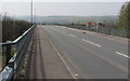
Road bridge over the A465 near Llechryd
The bridge carries the minor road from Princetown to Llechryd
over the A465 Heads of the Valleys Road in Caerphilly County Borough.
Image: © Jaggery
Taken: 15 Apr 2019
0.07 miles
6
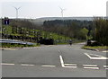
Wind farm access road near Llechryd
Ahead for Pen Bryn Oer Wind Farm.
Image: © Jaggery
Taken: 15 Apr 2019
0.07 miles
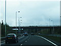
8
Bridge carrying road from Princetown to Llechrhyd over A465
The minor road also links an industrial estate north of the A465 with the Rhymney valley
Image: © David Smith
Taken: 7 Jul 2011
0.08 miles
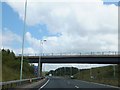
9
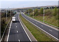
West along the A465 towards Bute Town
The A465 Heads of the Valleys Road viewed from this bridge. https://www.geograph.org.uk/photo/6125775
Image: © Jaggery
Taken: 15 Apr 2019
0.10 miles
10
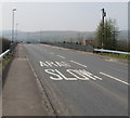
ARAF/SLOW on the approach to Llechryd
Welsh/English text painted on the road from Princetown on
the approach to the bridge over the A465 Heads of the Valleys Road.
Image: © Jaggery
Taken: 15 Apr 2019
0.10 miles