IMAGES TAKEN NEAR TO
Maerdy Industrial Estate South, TREDEGAR, NP22 5PH
Introduction
This page details the photographs taken nearby to Maerdy Industrial Estate South, NP22 5PH by members of the Geograph project.
The Geograph project started in 2005 with the aim of publishing, organising and preserving representative images for every square kilometre of Great Britain, Ireland and the Isle of Man.

There are currently over 7.5m images from over14,400 individuals and you can help contribute to the project by visiting https://www.geograph.org.uk
Image Map
Images are licensed for reuse under creativecommons.org/licenses/by-sa/2.0
Notes
- Clicking on the map will re-center to the selected point.
- The higher the marker number, the further away the image location is from the centre of the postcode.
Image Listing (41 Images Found)
Images are licensed for reuse under creativecommons.org/licenses/by-sa/2.0
Image
Details
Distance
1
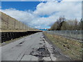
Road to Capital Valley Business Park, Pontlottyn
A view along part of the 300 metre long access road from the A469 to Capital Valley Business Park.
For much of its length, as here, the road is alongside the single-track Rhymney Line railway, separated by the grey fence on the right.
Image: © Jaggery
Taken: 19 Apr 2013
0.06 miles
2
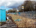
A signal sign, Pontlottyn
Viewed from the road http://www.geograph.org.uk/photo/3425259 from the A469 to Capital Valley Business Park.
On the right, alongside the single-track Rhymney Line, is a signal sign, which shows a representation
of a yellow distant signal. There is a similar sign at Barry Island railway station. http://www.geograph.org.uk/photo/1916995
Image: © Jaggery
Taken: 19 Apr 2013
0.07 miles
3
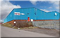
Slipperstore, Pontlottyn
Slipperstore is a factory shop located at the southern edge of Capital Valley Business Park.
Image: © Jaggery
Taken: 19 Apr 2013
0.07 miles
4

Puddlers Arms, Rhymney
This was one of 29 tied houses associated with the Rhymney Brewery which was established in 1839 by Andrew Buchan.
A puddler had a highly skilled and dangerous job in the iron works.
Image: © Robin Drayton
Taken: 10 Dec 2008
0.08 miles
5
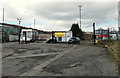
Security barrier, Capital Valley Business Park, Pontlottyn
Capital Valley Business Park is on the north side of the A469.
Image: © Jaggery
Taken: 19 Apr 2013
0.10 miles
7
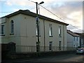
Moriah Chapel, Rhymney
This Welsh Independent chapel was built in 1841.
Image: © Robin Drayton
Taken: 10 Dec 2008
0.12 miles
8
K.J.Services Pontlottyn
Located in Capital Valley Business Park, K.J.Services specialise in plant rental for the construction and quarrying industries.
Image: © Jaggery
Taken: 19 Apr 2013
0.13 miles
9
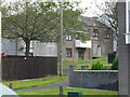
View into Idris Davies Place, Rhymney
A street named after the local poet.
How do they get an ambulance in there if they need to?
Image: © Jeremy Bolwell
Taken: 16 Sep 2012
0.13 miles
![Moriah Street [2], Rhymney](https://s1.geograph.org.uk/geophotos/01/10/09/1100945_2d67d2b1_120x120.jpg)