IMAGES TAKEN NEAR TO
Havards Row, TREDEGAR, NP22 5PA
Introduction
This page details the photographs taken nearby to Havards Row, NP22 5PA by members of the Geograph project.
The Geograph project started in 2005 with the aim of publishing, organising and preserving representative images for every square kilometre of Great Britain, Ireland and the Isle of Man.

There are currently over 7.5m images from over14,400 individuals and you can help contribute to the project by visiting https://www.geograph.org.uk
Image Map
Images are licensed for reuse under creativecommons.org/licenses/by-sa/2.0
Notes
- Clicking on the map will re-center to the selected point.
- The higher the marker number, the further away the image location is from the centre of the postcode.
Image Listing (152 Images Found)
Images are licensed for reuse under creativecommons.org/licenses/by-sa/2.0
Image
Details
Distance
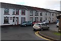
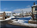
1
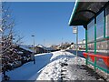
Havards Row
Ramsden Street on the left and Calvary Evangelical Church http://www.geograph.org.uk/photo/691860 on the right.
Image: © Robin Drayton
Taken: 22 Dec 2009
0.02 miles
2
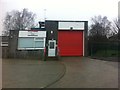
Rhymney Fire Station
Rhymney Fire Station is a station that is manned by Retained Firefighters. Firefighters do live within the Community. The Station is located in the Town of Rhymney. The primary area for the Fire Station is Rhymney, Rhymney Bridge, Princetown, Pontlottyn, Abertwysswg and Fochriw. The local area is rural. There are two mountains overlooking the Rhymney area, Capel Brithdir and Rhymney Common. The fire station is located on Havards Row.
Image: © Ethan Pitt
Taken: 2 Jan 2013
0.02 miles
3
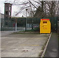
Yellow bin outside Rhymney Fire Station
For donations of items specified on the bin, proceeds from the
sale of which partly fund the work of the Fire Fighters Charity.
Image: © Jaggery
Taken: 12 Dec 2018
0.03 miles
4
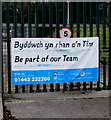
Be part of our Team, Rhymney Fire Station
The banner on the railings here https://www.geograph.org.uk/photo/5999022 shows
Be part of our Team - Be an on-call Firefighter at RHYMNEY Fire Station in your spare time.
The text is also in Welsh.
Image: © Jaggery
Taken: 12 Dec 2018
0.04 miles
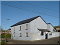
5
Glasbury House, Ramsden Street, Rhymney
With the wealth of information available on the internet in 2014, I thought it would be easy to find out the reason from the large Glasbury House name on the left, on the wall of 32 Ramsden Street. A former pub perhaps or a shop? But no such information was to be found. Of course, a house owner may give the property a name which has no connection with its earlier use...
Image: © Jaggery
Taken: 17 Jan 2014
0.04 miles
6
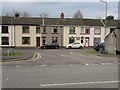
Ramsden Street houses, Rhymney
Viewed across the B4257 Havard's Row.
Image: © Jaggery
Taken: 12 Dec 2018
0.04 miles
7
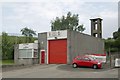
Rhymney Fire Station
Rhymney Fire Station, Havards Row, Rhymney is one of the fire stations that make up the South Wales Fire & Rescue Service
Image: © Kevin Hale
Taken: 4 Jun 2007
0.04 miles
8
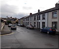
Ramsden Street, Rhymney
Ramsden Street is parallel with, and below, Havard's Row.
Image: © Jaggery
Taken: 17 Jan 2014
0.04 miles
9
The junction of Havards Row and Beulah Street
Showing part of Emmanuel Baptist Church http://www.geograph.org.uk/photo/1112590 with Mountbatten at the centre right.
Image: © Robin Drayton
Taken: 22 Dec 2009
0.04 miles
10
Emmanuel Baptist Church, Rhymney
The jackdaws were not straying far from their roost on this cold winter day.
Image: © Robin Drayton
Taken: 27 Dec 2008
0.04 miles