IMAGES TAKEN NEAR TO
Manest Street, TREDEGAR, NP22 5NH
Introduction
This page details the photographs taken nearby to Manest Street, NP22 5NH by members of the Geograph project.
The Geograph project started in 2005 with the aim of publishing, organising and preserving representative images for every square kilometre of Great Britain, Ireland and the Isle of Man.

There are currently over 7.5m images from over14,400 individuals and you can help contribute to the project by visiting https://www.geograph.org.uk
Image Map
Images are licensed for reuse under creativecommons.org/licenses/by-sa/2.0
Notes
- Clicking on the map will re-center to the selected point.
- The higher the marker number, the further away the image location is from the centre of the postcode.
Image Listing (310 Images Found)
Images are licensed for reuse under creativecommons.org/licenses/by-sa/2.0
Image
Details
Distance
1
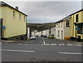
Down Manest Street, Rhymney
Signs facing the B4257 High Street show that Manest Street is not a through route for motor vehicles.
Image: © Jaggery
Taken: 12 Dec 2018
0.01 miles
2

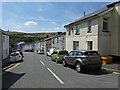
Up Manest Street, Rhymney
Manest Street ascends towards High Street.
Image: © Jaggery
Taken: 12 Dec 2018
0.01 miles
4

Manest Street, Rhymney
Taken from the High Street.
Image: © Robin Drayton
Taken: 27 Dec 2008
0.01 miles
5
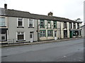
Part of the High Street, Rhymney
The cash point ATM is part of a Lloyds TSB branch and the adjacent buildings comprise a well kept terraced home and a few other buildings with commercial uses. Their landlord may need to look to his maintenance agreements and leases.
Image: © Jeremy Bolwell
Taken: 16 Sep 2012
0.02 miles
6
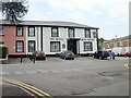
The Royal Arms Hotel, Rhymney
Located on High Street, viewed from Manest Street.
A recent makeover produced a brighter facade and a change of name from The Royal (pub).
Image: © Jaggery
Taken: 7 May 2010
0.02 miles
7
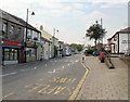
High Street Rhymney
The view north along High Street. On the left, beside the zebra crossing, is the post office http://www.geograph.org.uk/photo/1846890 ; on the right is The Royal Arms Hotel.http://www.geograph.org.uk/photo/1848247
Image: © Jaggery
Taken: 7 May 2010
0.02 miles
8
![Helping Hands Shop[A], High Street, Rhymney](https://s3.geograph.org.uk/geophotos/05/99/92/5999299_f815b56d_120x120.jpg)
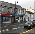
Helping Hands Shop[A], High Street, Rhymney
One of two High Street Helping Hands shops on opposite corners of Manest Street in December 2018.
https://www.geograph.org.uk/photo/5999300 to the other one. Based in the five communities of Rhymney, Pontlottyn, Abertysswg, Deri and Fochriw, Helping Hands (Rhymney Cancer Self-Help Group) is a registered charity founded in 1994.
Image: © Jaggery
Taken: 12 Dec 2018
0.03 miles
9
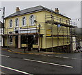
Scaffolding on a Rhymney corner
On the corner of High Street and Manest Street on April 5th 2019.
Image: © Jaggery
Taken: 5 Apr 2019
0.03 miles
10
Ladbrokes, Greenacres store and post office, High Street, Rhymney
The post office is inside the Lifestyle Express Greenacres Store on the right.
Image: © Jaggery
Taken: 17 Jan 2014
0.03 miles