IMAGES TAKEN NEAR TO
Maerdy View, TREDEGAR, NP22 5LH
Introduction
This page details the photographs taken nearby to Maerdy View, NP22 5LH by members of the Geograph project.
The Geograph project started in 2005 with the aim of publishing, organising and preserving representative images for every square kilometre of Great Britain, Ireland and the Isle of Man.

There are currently over 7.5m images from over14,400 individuals and you can help contribute to the project by visiting https://www.geograph.org.uk
Image Map
Images are licensed for reuse under creativecommons.org/licenses/by-sa/2.0
Notes
- Clicking on the map will re-center to the selected point.
- The higher the marker number, the further away the image location is from the centre of the postcode.
Image Listing (47 Images Found)
Images are licensed for reuse under creativecommons.org/licenses/by-sa/2.0
Image
Details
Distance
1
Maerdy View bungalows, Rhymney
Viewed from the minor road from Rhymney to Abertysswg.
Image: © Jaggery
Taken: 4 May 2019
0.09 miles
2
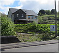
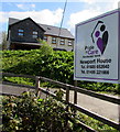
Newport House, Abertysswg
Pride In Care Residential Home in Newport House.
Image: © Jaggery
Taken: 4 May 2019
0.09 miles
3
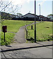
Path ascending to Maerdy View, Rhymney
From the minor road from Rhymney to Abertysswg.
Image: © Jaggery
Taken: 4 May 2019
0.10 miles
4

Fork in the path towards Maerdy View, Rhymney
Ascending from the minor road from Rhymney to Abertysswg.
Image: © Jaggery
Taken: 4 May 2019
0.10 miles
5
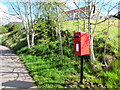
Queen Elizabeth II postbox near Maerdy View, Rhymney
Located here. https://www.geograph.org.uk/photo/6141986
Image: © Jaggery
Taken: 4 May 2019
0.11 miles
6
Pride in Care Residential Home, Newport House name sign, Abertysswg
On the right here. https://www.geograph.org.uk/photo/6141758
Image: © Jaggery
Taken: 4 May 2019
0.11 miles
7
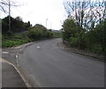
Bend in the minor road from Rhymney to Abertysswg
Ahead for Newport House https://www.geograph.org.uk/photo/6141758 on the road to Abertysswg.
Image: © Jaggery
Taken: 4 May 2019
0.12 miles
8
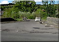
Two boulders across a side road near Abertysswg
Viewed across the minor road from Rhymney to Abertysswg.
Image: © Jaggery
Taken: 4 May 2019
0.13 miles
9
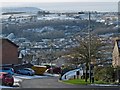
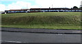
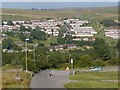
View over Pontlottyn from Rhymney
The Pontlottyn railway viaduct http://www.geograph.org.uk/photo/535242 is in the centre of the picture.
The outskirts of Fochriw http://www.geograph.org.uk/photo/653445 can be seen on the horizon at the upper right above the lamp post.
Image: © Robin Drayton
Taken: 16 Jan 2013
0.13 miles
10
View across the Rhymney Valley
A cattle grid on the edge of Gelligaer Common.
This minor road is a very steep descent down to Pontlottyn.
The houses on the far side are the Tan-y-Bryn estate in Lower Rhymney.
Image: © Robin Drayton
Taken: 4 Sep 2013
0.13 miles