IMAGES TAKEN NEAR TO
Tan Y Bryn, TREDEGAR, NP22 5LE
Introduction
This page details the photographs taken nearby to Tan Y Bryn, NP22 5LE by members of the Geograph project.
The Geograph project started in 2005 with the aim of publishing, organising and preserving representative images for every square kilometre of Great Britain, Ireland and the Isle of Man.

There are currently over 7.5m images from over14,400 individuals and you can help contribute to the project by visiting https://www.geograph.org.uk
Image Map
Images are licensed for reuse under creativecommons.org/licenses/by-sa/2.0
Notes
- Clicking on the map will re-center to the selected point.
- The higher the marker number, the further away the image location is from the centre of the postcode.
Image Listing (14 Images Found)
Images are licensed for reuse under creativecommons.org/licenses/by-sa/2.0
Image
Details
Distance
1
Hill Street, Rhymney
This is the top of Hill Street (B4256) just before Rhymney and Bedwellty Common http://www.geograph.org.uk/photo/499800 .
Image: © Robin Drayton
Taken: 18 Feb 2009
0.02 miles
2
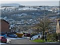
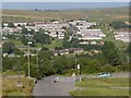
View over Pontlottyn from Rhymney
The Pontlottyn railway viaduct http://www.geograph.org.uk/photo/535242 is in the centre of the picture.
The outskirts of Fochriw http://www.geograph.org.uk/photo/653445 can be seen on the horizon at the upper right above the lamp post.
Image: © Robin Drayton
Taken: 16 Jan 2013
0.05 miles
3
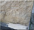
Ordnance Survey Cut Mark
This OS cut mark can be found on No101 Hill Street. It marks a point 305.376m above mean sea level.
Image: © Adrian Dust
Taken: 29 Sep 2018
0.07 miles
5
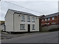
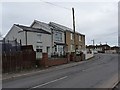
Former Tredegar Arms, Hill Street, Rhymney
This was once a public house that was tied to the local brewery.
For another one nearby see http://www.geograph.org.uk/photo/1101062 .
Image: © Robin Drayton
Taken: 18 Feb 2009
0.08 miles
7
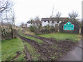
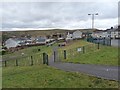
Cattle Grid onto Rhymney & Bedwellty Common
Up the hill from Rhymney on the B4256 to Tredegar. The view is towards Pontlottyn.
Image: © Robin Drayton
Taken: 18 Jul 2007
0.19 miles
8
![Hill Street [3], Rhymney](https://s3.geograph.org.uk/geophotos/01/09/05/1090507_f1152176_120x120.jpg)
Hill Street [3], Rhymney
A little higher up the street from the view shown here http://www.geograph.org.uk/photo/1090503 .
Image: © Robin Drayton
Taken: 10 Dec 2008
0.20 miles
9
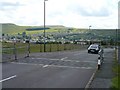
View across the Rhymney Valley
A cattle grid on the edge of Gelligaer Common.
This minor road is a very steep descent down to Pontlottyn.
The houses on the far side are the Tan-y-Bryn estate in Lower Rhymney.
Image: © Robin Drayton
Taken: 4 Sep 2013
0.21 miles
10
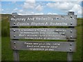
Sign onto Rhymney & Bedwellty Common
Taken with my back towards the Cattle Grid shown in image Image
Image: © Robin Drayton
Taken: 18 Jul 2007
0.21 miles