IMAGES TAKEN NEAR TO
Hafod-y-Mynydd, TREDEGAR, NP22 5JQ
Introduction
This page details the photographs taken nearby to Hafod-y-Mynydd, NP22 5JQ by members of the Geograph project.
The Geograph project started in 2005 with the aim of publishing, organising and preserving representative images for every square kilometre of Great Britain, Ireland and the Isle of Man.

There are currently over 7.5m images from over14,400 individuals and you can help contribute to the project by visiting https://www.geograph.org.uk
Image Map
Images are licensed for reuse under creativecommons.org/licenses/by-sa/2.0
Notes
- Clicking on the map will re-center to the selected point.
- The higher the marker number, the further away the image location is from the centre of the postcode.
Image Listing (20 Images Found)
Images are licensed for reuse under creativecommons.org/licenses/by-sa/2.0
Image
Details
Distance
1
![Hill Street [3], Rhymney](https://s3.geograph.org.uk/geophotos/01/09/05/1090507_f1152176_120x120.jpg)
Hill Street [3], Rhymney
A little higher up the street from the view shown here http://www.geograph.org.uk/photo/1090503 .
Image: © Robin Drayton
Taken: 10 Dec 2008
0.09 miles
2
![Hill Street [2], Rhymney](https://s3.geograph.org.uk/geophotos/01/09/05/1090503_c0ff6a42_120x120.jpg)
Hill Street [2], Rhymney
The modern detached house contrasts with the Victorian terraced housing opposite.
Image: © Robin Drayton
Taken: 10 Dec 2008
0.11 miles
4
![Hill Street [1], Rhymney](https://s0.geograph.org.uk/geophotos/01/09/04/1090496_a30e8fb8_120x120.jpg)
Hill Street [1], Rhymney
Pre 20th century terraced houses.
For a view looking up the street from beyond the bend in the distance see http://www.geograph.org.uk/photo/1069272 .
Image: © Robin Drayton
Taken: 10 Dec 2008
0.14 miles
5
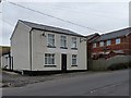
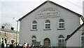
Former Tredegar Arms, Hill Street, Rhymney
This was once a public house that was tied to the local brewery.
For another one nearby see http://www.geograph.org.uk/photo/1101062 .
Image: © Robin Drayton
Taken: 18 Feb 2009
0.15 miles
6
![Moriah Street [1], Rhymney](https://s1.geograph.org.uk/geophotos/01/10/09/1100941_db80030c_120x120.jpg)
Moriah Street [1], Rhymney
Taken from the junction with Hill Street.
Image: © Robin Drayton
Taken: 10 Dec 2008
0.15 miles
7
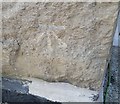
Ordnance Survey Cut Mark
This OS cut mark can be found on No101 Hill Street. It marks a point 305.376m above mean sea level.
Image: © Adrian Dust
Taken: 29 Sep 2018
0.16 miles
8
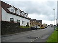
Hill Street
The B4256 from Rhymney which goes up onto Rhymney and Bedwellty Common http://www.geograph.org.uk/photo/640252 and then down to Tredegar http://www.geograph.org.uk/photo/723221 .
The building on the left is St Mark's Cottage which was formerly St Mark's Church.
Image: © Robin Drayton
Taken: 23 Aug 2008
0.16 miles
9
Jerusalem Chapel, Rhymney
A Welsh Baptist chapel built in 1841 and modified in 1876.
Demolished late 20th century.
Image: © P Hooper
Taken: 7 Feb 1976
0.17 miles
![Moriah Street [2], Rhymney](https://s1.geograph.org.uk/geophotos/01/10/09/1100945_2d67d2b1_120x120.jpg)