IMAGES TAKEN NEAR TO
Rhymney, TREDEGAR, NP22 5HA
Introduction
This page details the photographs taken nearby to NP22 5HA by members of the Geograph project.
The Geograph project started in 2005 with the aim of publishing, organising and preserving representative images for every square kilometre of Great Britain, Ireland and the Isle of Man.

There are currently over 7.5m images from over14,400 individuals and you can help contribute to the project by visiting https://www.geograph.org.uk
Image Map
Images are licensed for reuse under creativecommons.org/licenses/by-sa/2.0
Notes
- Clicking on the map will re-center to the selected point.
- The higher the marker number, the further away the image location is from the centre of the postcode.
Image Listing (4 Images Found)
Images are licensed for reuse under creativecommons.org/licenses/by-sa/2.0
Image
Details
Distance
1
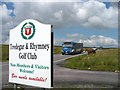
Tredegar & Rhymney Golf Club Sign
The Tredegar & Rhymney Golf Club is on Rhymney and Bedwellty Common and situated on an exposed site at over 350m above sea level.
Image: © Robin Drayton
Taken: 18 Jul 2007
0.07 miles
2
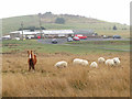
Horse and sheep near the Tredegar & Rhymney Golf Club
Image: © Gareth James
Taken: 1 Mar 2019
0.09 miles
3
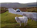
Motorist and Sheep, Rhymney and Bedwellty Common
Christmas Day 2013.
With a sprinkling of snow on the distant hills.
For a similar picture taken six years earlier see http://www.geograph.org.uk/photo/640252.
Image: © Robin Drayton
Taken: 25 Dec 2013
0.23 miles
4
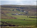
Looking across Cwm Tyswg
Christmas Day 2013. With a sprinkling of snow on the distant hills.
Waun-Tysswg Farm is in the centre of the picture. For a reverse view taken a month earlier see http://www.geograph.org.uk/photo/3754511 .
Image: © Robin Drayton
Taken: 25 Dec 2013
0.24 miles