IMAGES TAKEN NEAR TO
Gladstone Terrace, TREDEGAR, NP22 5EL
Introduction
This page details the photographs taken nearby to Gladstone Terrace, NP22 5EL by members of the Geograph project.
The Geograph project started in 2005 with the aim of publishing, organising and preserving representative images for every square kilometre of Great Britain, Ireland and the Isle of Man.

There are currently over 7.5m images from over14,400 individuals and you can help contribute to the project by visiting https://www.geograph.org.uk
Image Map (Loading...)


Getting Data...Please wait
Leaflet Map data © OpenStreetMap
Images are licensed for reuse under creativecommons.org/licenses/by-sa/2.0
Notes
- Clicking on the map will re-center to the selected point.
- The higher the marker number, the further away the image location is from the centre of the postcode.
Image Listing (147 Images Found)
Images are licensed for reuse under creativecommons.org/licenses/by-sa/2.0
Image
Details
Distance
1
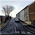
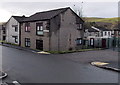
Up Gladstone Terrace, Rhymney
Gladstone Terrace ascends from the B4257 Glan-yr-afon.
Image: © Jaggery
Taken: 17 Jan 2014
0.01 miles
2
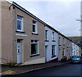
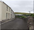
Gladstone Terrace houses, Rhymney
Gladstone Terrace descends from the corner of Harcourt Place towards Glan-yr-afon.
Image: © Jaggery
Taken: 17 Jan 2014
0.01 miles
3
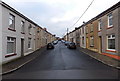
Harcourt Place, Rhymney
Looking north towards Gladstone Terrace.
Image: © Jaggery
Taken: 17 Jan 2014
0.02 miles
4
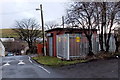
Gladstone Terrace electricity substation, Rhymney
The identifier on the Western Power Distribution electricity substation is
GLADSTONE TERR RHYMNEY S/S 552388.
Image: © Jaggery
Taken: 17 Jan 2014
0.02 miles
5
Glan-yr-afon flats in Rhymney
Viewed from the corner of Gladstone Terrace. The road is part of the B4257.
Image: © Jaggery
Taken: 17 Jan 2014
0.03 miles
6
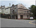
Scaffolding on a Rhymney corner
On the house on the corner of Carno Street and the B4257 in July 2019.
Image: © Jaggery
Taken: 11 Jul 2019
0.03 miles
7
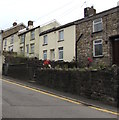
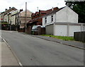
Houses on the south side of Carno Street, Rhymney
Alongside the ascent from the valley of the Rhymney River towards Upper High Street.
Image: © Jaggery
Taken: 11 Jul 2019
0.03 miles
8
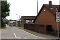
Start of the 20 zone, Carno Street, Rhymney
The 30mph speed limit on the B4257 Carno Street drops to 20mph on the approach to Upper Rhymney Primary School.
Image: © Jaggery
Taken: 11 Jul 2019
0.03 miles
9
Houses above the south side of Carno Street, Rhymney
Viewed from the corner of Bryn Seion Street. The main roadway is below the wall on the right.
Image: © Jaggery
Taken: 11 Jul 2019
0.04 miles
10
Up Carno Street, Rhymney
From the valley of the Rhymney River, Carno Street ascends towards Upper High Street.
Image: © Jaggery
Taken: 11 Jul 2019
0.04 miles