IMAGES TAKEN NEAR TO
Glan-y-Nant, TREDEGAR, NP22 5DF
Introduction
This page details the photographs taken nearby to Glan-y-Nant, NP22 5DF by members of the Geograph project.
The Geograph project started in 2005 with the aim of publishing, organising and preserving representative images for every square kilometre of Great Britain, Ireland and the Isle of Man.

There are currently over 7.5m images from over14,400 individuals and you can help contribute to the project by visiting https://www.geograph.org.uk
Image Map
Images are licensed for reuse under creativecommons.org/licenses/by-sa/2.0
Notes
- Clicking on the map will re-center to the selected point.
- The higher the marker number, the further away the image location is from the centre of the postcode.
Image Listing (121 Images Found)
Images are licensed for reuse under creativecommons.org/licenses/by-sa/2.0
Image
Details
Distance
1
Glan-y-nant, Rhymney
Glan-y-nant is a cul-de-sac on the west side of the B4257.
Image: © Jaggery
Taken: 5 Apr 2019
0.01 miles
2
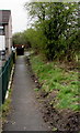
Path past the edge of Glan-y-nant, Rhymney
From the west side of the B4257 past the northern edge of Glan-y-nant houses.
Image: © Jaggery
Taken: 5 Apr 2019
0.02 miles
3
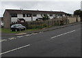
Row of houses, Glan-y-nant, Rhymney
Viewed across the B4257.
Image: © Jaggery
Taken: 11 Jul 2019
0.02 miles
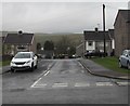
4
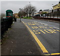
Traffic calming on the B4257, Rhymney
Vehicles must stop behind the broken white lines to give way to oncoming vehicles.
The sign text is also in Welsh.
Image: © Jaggery
Taken: 5 Apr 2019
0.03 miles
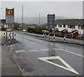
5
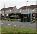
Aneurin Terrace bus stop and shelter, Rhymney
Alongside the B4257 near Aneurin Terrace on the right.
Allotments perimeter railings are on the left.
Image: © Jaggery
Taken: 5 Apr 2019
0.03 miles
6
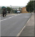
Horse and rider on the B4257, Rhymney
Approaching a bus stop. A red-edged horses warning sign https://www.geograph.org.uk/photo/6110968 is in the background.
Image: © Jaggery
Taken: 11 Jul 2019
0.03 miles
7
Pen-y-dre bus stop and shelter, Rhymney
In July 2019 the stop alongside the B4257 is for buses to Bargoed on Stagecoach
routes 1, 2 and 3 and Harris Coaches Route 20 to Rhymney railway station.
Image: © Jaggery
Taken: 11 Jul 2019
0.03 miles
8
Boulders alongside the B4257 in the north of Rhymney
On the west side of the B4257 between a bus stop and shelter out of shot on the left and allotments on the right.
Image: © Jaggery
Taken: 5 Apr 2019
0.04 miles
9
Warning sign - horses, Ael-y-bryn near Rhymney
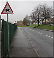
Alongside the B4257 at an allotments perimeter fence.
Image: © Jaggery
Taken: 5 Apr 2019
0.04 miles
10
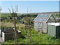
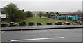
Community Allotment, Rhymney
An exposed site at over 310m above sea level.
Image: © Robin Drayton
Taken: 22 Aug 2007
0.05 miles