IMAGES TAKEN NEAR TO
Tysswg Lane, TREDEGAR, NP22 5BJ
Introduction
This page details the photographs taken nearby to Tysswg Lane, NP22 5BJ by members of the Geograph project.
The Geograph project started in 2005 with the aim of publishing, organising and preserving representative images for every square kilometre of Great Britain, Ireland and the Isle of Man.

There are currently over 7.5m images from over14,400 individuals and you can help contribute to the project by visiting https://www.geograph.org.uk
Image Map
Images are licensed for reuse under creativecommons.org/licenses/by-sa/2.0
Notes
- Clicking on the map will re-center to the selected point.
- The higher the marker number, the further away the image location is from the centre of the postcode.
Image Listing (111 Images Found)
Images are licensed for reuse under creativecommons.org/licenses/by-sa/2.0
Image
Details
Distance
1
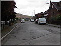
Westville, Abertysswg
Eastern end of a long dead-end road viewed from Station Road.
Image: © Jaggery
Taken: 25 Apr 2019
0.05 miles
2
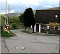
Top end of Tysswg Lane, Abertysswg
Tysswg Lane descends from the corner of Station Road and Westville.
Image: © Jaggery
Taken: 25 Apr 2019
0.05 miles
3

Cycle route 486 direction sign, Station Road, Abertysswg
The sign points left towards Westville. https://www.geograph.org.uk/photo/6133327 National Cycle Network Route 468
extends from Bargoed north to the Rhymney Valley via New Tredegar.
Image: © Jaggery
Taken: 25 Apr 2019
0.06 miles
4
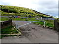
Metal barrier across an entrance to Maes McLaren, Abertysswg
Viewed from Station Road near the corner of Westville.
Image: © Jaggery
Taken: 25 Apr 2019
0.06 miles
5
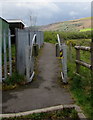
Inwardly-sloping barrier, Maes McLaren, Abertysswg
Across a path at the edge of Maes McLaren.
Image: © Jaggery
Taken: 25 Apr 2019
0.06 miles
6
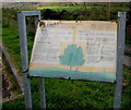
Plant! information board, Maes McLaren, Abertysswg
The board states You are standing in a Plant! wood - one of a few very special places chosen to help us celebrate new life in Wales. For every child born or adopted from January 1st 2008, a tree is being planted, creating a national forest of native broadleaved trees.
Plant! is a Welsh Government scheme inspired by 11-year-old Cardiff schoolgirl Natalie Vaughan who wrote to her local Welsh Assembly Member suggesting this would be a good way to make young people think about their environment and the role they have in protecting it.
Image: © Jaggery
Taken: 25 Apr 2019
0.06 miles
7
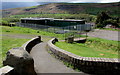
Single-storey buildings in Maes McLaren, Abertysswg
Maes McLaren is the home ground of Abertysswg Falcons Rugby Football Club.
Image: © Jaggery
Taken: 25 Apr 2019
0.06 miles
8
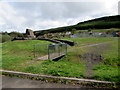
Green bridge on the approach to McLaren Miners' Memorial in Abertysswg
https://www.geograph.org.uk/photo/6134723 to a closer view of the Memorial.
Image: © Jaggery
Taken: 25 Apr 2019
0.06 miles
9
Alfred Street, Abertysswg
Dead-end street on the west side of Station Road.
Image: © Jaggery
Taken: 25 Apr 2019
0.06 miles
10
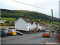
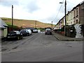
Station Road, Abertysswg
But no station. The reason is in the distance on the right. Image
Image: © Robin Drayton
Taken: 23 Aug 2008
0.07 miles