IMAGES TAKEN NEAR TO
Charles Street, TREDEGAR, NP22 5AY
Introduction
This page details the photographs taken nearby to Charles Street, NP22 5AY by members of the Geograph project.
The Geograph project started in 2005 with the aim of publishing, organising and preserving representative images for every square kilometre of Great Britain, Ireland and the Isle of Man.

There are currently over 7.5m images from over14,400 individuals and you can help contribute to the project by visiting https://www.geograph.org.uk
Image Map
Images are licensed for reuse under creativecommons.org/licenses/by-sa/2.0
Notes
- Clicking on the map will re-center to the selected point.
- The higher the marker number, the further away the image location is from the centre of the postcode.
Image Listing (114 Images Found)
Images are licensed for reuse under creativecommons.org/licenses/by-sa/2.0
Image
Details
Distance
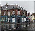
1
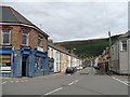
Charles Street
Built about 1900 this was one of the first streets in Abertysswg.
Image: © Robin Drayton
Taken: 23 Aug 2008
0.01 miles
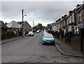
2

West along Charles Street, Abertysswg
Ahead for The Green. The Hill Road junction is on the right.
Image: © Jaggery
Taken: 25 Apr 2019
0.01 miles
3
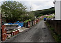
A back lane in Abertysswg
From the east side of Station Road towards Charles Street.
Image: © Jaggery
Taken: 25 Apr 2019
0.02 miles
4
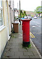
Queen Elizabeth II pillarbox, Charles Street, Abertysswg
Outside the former village post office which in April 2019 is in this https://www.geograph.org.uk/photo/6132625
convenience store on the opposite side of the road.
Image: © Jaggery
Taken: 25 Apr 2019
0.02 miles
5
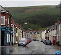
Charles Street, Abertysswg
East along Charles Street from the corner of Station Road.
The village post office https://www.geograph.org.uk/photo/6132625 is on the left.
Image: © Jaggery
Taken: 25 Apr 2019
0.02 miles
6
The Green convenience store & post office, Abertysswg
In April 2019 Abertysswg's post office is part of this Charles Street convenience store on the corner of The Green.
Image: © Jaggery
Taken: 25 Apr 2019
0.03 miles
7
Up Station Road, Abertysswg
Station Road ascends towards Charles Street.
Image: © Jaggery
Taken: 25 Apr 2019
0.03 miles
8
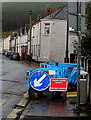
Ffordd droed ar gau/Footpath closed, Charles Street, Abertysswg
Welsh/English temporary sign viewed on April 25th 2019.
Image: © Jaggery
Taken: 25 Apr 2019
0.04 miles
9
View of central Abertysswg
From this https://www.geograph.org.uk/photo/6141391 bench near McLaren Cottages.
Image: © Jaggery
Taken: 4 May 2019
0.04 miles
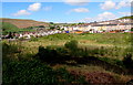
10
Overlooking Abertysswg
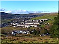
Pontlottyn is in the distance on the far side of the Rhymney Valley.
Image: © Robin Drayton
Taken: 22 Nov 2013
0.04 miles