IMAGES TAKEN NEAR TO
Greensway, TREDEGAR, NP22 5AP
Introduction
This page details the photographs taken nearby to Greensway, NP22 5AP by members of the Geograph project.
The Geograph project started in 2005 with the aim of publishing, organising and preserving representative images for every square kilometre of Great Britain, Ireland and the Isle of Man.

There are currently over 7.5m images from over14,400 individuals and you can help contribute to the project by visiting https://www.geograph.org.uk
Image Map
Images are licensed for reuse under creativecommons.org/licenses/by-sa/2.0
Notes
- Clicking on the map will re-center to the selected point.
- The higher the marker number, the further away the image location is from the centre of the postcode.
Image Listing (45 Images Found)
Images are licensed for reuse under creativecommons.org/licenses/by-sa/2.0
Image
Details
Distance
1
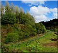
Path on a bank of Nant Tyswg, Abertysswg
A tributary of the Rhymney River, Nant Tyswg gave the village its name -
Abertyswg (mouth of the Tyswg) in Welsh, Abertysswg in English.
Image: © Jaggery
Taken: 25 Apr 2019
0.08 miles
2
Steps up from Charles Street, Abertysswg
Ascending to Barkley Street.
Image: © Jaggery
Taken: 25 Apr 2019
0.10 miles
3
Warning sign - humps, Abertysswg
On the approach to houses at the eastern end of Charles Street.
Image: © Jaggery
Taken: 25 Apr 2019
0.10 miles
4
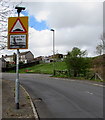
CCTV in operation notice, Charles Street, Abertysswg
The notice is on the lamppost at the end of a row of Charles Street houses.
Image: © Jaggery
Taken: 4 May 2019
0.11 miles
5
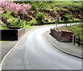
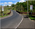
Brick sides of a road bridge, Abertysswg
This part of the road is between Charles Street (behind the camera) and McLaren Cottages. https://www.geograph.org.uk/photo/6141182
The bridge spans a depression on the northeast side of this https://www.geograph.org.uk/photo/6133611 body of water.
Image: © Jaggery
Taken: 25 Apr 2019
0.11 miles
6
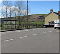
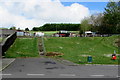
Bus stop and shelter at the eastern end of Charles Street, Abertysswg
This stop for buses to Bargoed or Tredegar or Merthyr Tydfil is at the bus turning point near the eastern edge of the village.
Image: © Jaggery
Taken: 4 May 2019
0.11 miles
7
Three speed bumps across Charles Street, Abertysswg
At the eastern end of Charles Street. Ahead for the centre of Abertysswg,
behind the camera for McLaren Cottages. https://www.geograph.org.uk/photo/6141182
Image: © Jaggery
Taken: 25 Apr 2019
0.12 miles
8
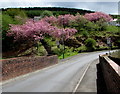
Pink blossom, Abertysswg
Viewed on April 25th 2019.
Image: © Jaggery
Taken: 25 Apr 2019
0.12 miles
9
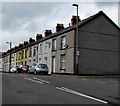
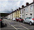
Houses at the eastern end of Charles Street, Abertysswg
At the eastern edge of the village.
Image: © Jaggery
Taken: 25 Apr 2019
0.12 miles
10
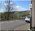
From 30 to 20 in the east of Abertysswg
The speed limit drops to 20mph. PARTH is Welsh for ZONE.
Image: © Jaggery
Taken: 4 May 2019
0.12 miles