IMAGES TAKEN NEAR TO
Park Place, TREDEGAR, NP22 4LQ
Introduction
This page details the photographs taken nearby to Park Place, NP22 4LQ by members of the Geograph project.
The Geograph project started in 2005 with the aim of publishing, organising and preserving representative images for every square kilometre of Great Britain, Ireland and the Isle of Man.

There are currently over 7.5m images from over14,400 individuals and you can help contribute to the project by visiting https://www.geograph.org.uk
Image Map
Images are licensed for reuse under creativecommons.org/licenses/by-sa/2.0
Notes
- Clicking on the map will re-center to the selected point.
- The higher the marker number, the further away the image location is from the centre of the postcode.
Image Listing (82 Images Found)
Images are licensed for reuse under creativecommons.org/licenses/by-sa/2.0
Image
Details
Distance
1
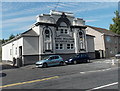
Mark Williams Snooker Club, Tredegar
Previously named Tredegar Snooker Centre, this building in Park Place has been Mark Williams Snooker Club since 2010. It is owned by Mark Williams MBE, a Welsh professional snooker player. He was World Snooker Champion twice, in 2000 and 2003.
Image: © Jaggery
Taken: 5 Sep 2013
0.04 miles
2
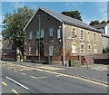
Venue 1 and Kidz R Us, Tredegar
The former Presbyterian Park Place Chapel is now Venue 1, a party & conference venue and also the home of Kidz R Us, where a wide variety of weekly classes for children take place. There are classes for drama, street dance, choir & vocal coaching, karate, Zumba etc.
Image: © Jaggery
Taken: 5 Sep 2013
0.04 miles
3
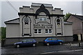
Mark Williams Snooker Club, Vale Terrace, Georgetown
Image: © Ian S
Taken: 24 May 2014
0.05 miles
4

Nisa Local and Georgetown post office, Tredegar
Viewed across Park Place.
Image: © Jaggery
Taken: 5 Sep 2013
0.06 miles
5
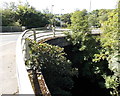
Road bridge over the Sirhowy, Tredegar
View from Park Place. The river here flows on the east side of the A4048.
Image: © Jaggery
Taken: 5 Sep 2013
0.07 miles
6
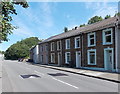
Park Place houses, Georgetown, Tredegar
The houses in this part of Park Place face a fence and trees lining the east bank of the Sirhowy River.
Image: © Jaggery
Taken: 5 Sep 2013
0.10 miles
7
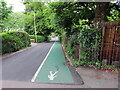
Ffordd i gerddwyr / Way for pedestrians
Rhan o'r heol wedi ei neilltuo i gerddwyr oherwydd prinder pafin.
Part of the road designated for pedestrians due to the lack of a pavement.
Image: © Alan Richards
Taken: 22 May 2022
0.10 miles
8
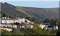
Hillside houses, Georgetown
A view from the centre of Tredegar across the Sirhowy Valley.
This is the view to the right of that shown here http://www.geograph.org.uk/photo/3716726 .
Image: © Robin Drayton
Taken: 23 Oct 2013
0.10 miles
9
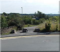
Boulders across a path from Stable Lane, Tredegar
Viewed across Stable Lane. Three boulders prevent cars or lorries using the path.
Image: © Jaggery
Taken: 5 Sep 2013
0.11 miles
10
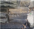
Ordnance Survey Cut Mark
This OS cut mark can be found on the wall NE side of Poplar Road. It marks a point 292.852m above mean sea level.
Image: © Adrian Dust
Taken: 27 Aug 2018
0.11 miles