IMAGES TAKEN NEAR TO
Roderick Hill Court, TREDEGAR, NP22 4EZ
Introduction
This page details the photographs taken nearby to Roderick Hill Court, NP22 4EZ by members of the Geograph project.
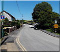
The Geograph project started in 2005 with the aim of publishing, organising and preserving representative images for every square kilometre of Great Britain, Ireland and the Isle of Man.

There are currently over 7.5m images from over14,400 individuals and you can help contribute to the project by visiting https://www.geograph.org.uk
Image Map
Images are licensed for reuse under creativecommons.org/licenses/by-sa/2.0
Notes
- Clicking on the map will re-center to the selected point.
- The higher the marker number, the further away the image location is from the centre of the postcode.
Image Listing (104 Images Found)
Images are licensed for reuse under creativecommons.org/licenses/by-sa/2.0
Image
Details
Distance
1
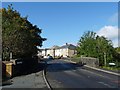
Pont y Widw, Dukestown, Tredegar
This bridge crosses the River Sirhowy.
On the right is an information board and signpost for a walk to Image
Image: © Robin Drayton
Taken: 3 Oct 2012
0.05 miles
2
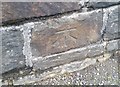
Ordnance Survey Cut Mark
This OS cut mark can be found on the north parapet of the River Sirhowy Bridge. It marks a point 327.642m above mean sea level.
Image: © Adrian Dust
Taken: 27 Aug 2018
0.06 miles
3
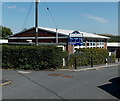
St Joseph's Catholic Primary School, Tredegar
The school is set back from the east side of Ashvale, near Merthyr Road.
Image: © Jaggery
Taken: 22 Aug 2013
0.11 miles
4
Station Road bungalows, Tredegar
Decades ago, Station Road led to Nantybwch railway station, long since demolished.
Now the road ends near the edge of the A465 Heads of the Valleys Road.
Image: © Jaggery
Taken: 22 Aug 2013
0.11 miles
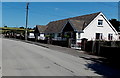
5
Station Road, Tredegar
The sign on the left shows that Station Road is now a no through road. 150 metres ahead, the road ends near the edge of the A465 Heads of the Valleys Road.
Old maps show that decades ago, Station Road led to Nantybwch railway station, where passenger services ceased in 1960. The long since demolished station was about 350 metres NW of the camera.
Image: © Jaggery
Taken: 22 Aug 2013
0.12 miles
6
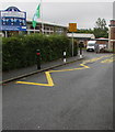
Zigzag yellow markings near a school entrance, Ashvale, Tredegar
Marking the Keep Clear Zone (no parking or stopping)
near the entrance to St Joseph's Catholic Primary School.
Image: © Jaggery
Taken: 19 Jul 2019
0.12 miles
7
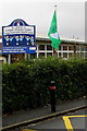
St Joseph's Catholic Primary School name sign and flag, Ashvale, Tredegar
The sign on the left here https://www.geograph.org.uk/photo/6215429 shows that the school name is Ysgol Gynradd Joseff Sant in Welsh.
Image: © Jaggery
Taken: 19 Jul 2019
0.12 miles
8
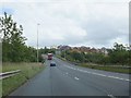
A465 crossing Sirhowy valley
The Heads of the Valleys Road descends into the valley and crosses the infant Sirhowy river; on the right are housing estates at Duke's Meadow
Image: © David Smith
Taken: 7 Jul 2011
0.12 miles
9
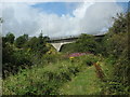
Heads of the Valleys Road
Crossing Sirhowy River at Dukes Meadow.
Image: © Burgess Von Thunen
Taken: 12 Aug 2012
0.12 miles
10
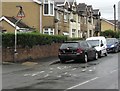
Zebra crossing warning sign, Merthyr Road, Ashvale, Tredegar
On the approach to these https://www.geograph.org.uk/photo/6215168 twin zebra crossings.
Image: © Jaggery
Taken: 19 Jul 2019
0.13 miles