IMAGES TAKEN NEAR TO
Stable Lane, TREDEGAR, NP22 4BU
Introduction
This page details the photographs taken nearby to Stable Lane, NP22 4BU by members of the Geograph project.
The Geograph project started in 2005 with the aim of publishing, organising and preserving representative images for every square kilometre of Great Britain, Ireland and the Isle of Man.

There are currently over 7.5m images from over14,400 individuals and you can help contribute to the project by visiting https://www.geograph.org.uk
Image Map
Images are licensed for reuse under creativecommons.org/licenses/by-sa/2.0
Notes
- Clicking on the map will re-center to the selected point.
- The higher the marker number, the further away the image location is from the centre of the postcode.
Image Listing (98 Images Found)
Images are licensed for reuse under creativecommons.org/licenses/by-sa/2.0
Image
Details
Distance
1
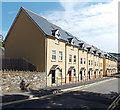
Southern edge of St James Parade, Tredegar
Viewed across Stable Lane. St James Parade http://www.geograph.org.uk/photo/3639056 is a recently-built
housing development near the SE corner of Bedwellty Park.
Image: © Jaggery
Taken: 5 Sep 2013
0.02 miles
2
St James Parade, Tredegar
Recently-built housing viewed across Stable Lane, near the SE corner of Bedwellty Park.
Image: © Jaggery
Taken: 5 Sep 2013
0.04 miles
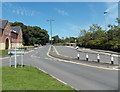
3
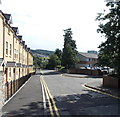
Stable Lane, Tredegar
This part of Stable Lane is between new housing http://www.geograph.org.uk/photo/3639069 on the left
and the entrance to Tredegar Comprehensive School and Leisure Centre on the right.
Image: © Jaggery
Taken: 5 Sep 2013
0.04 miles
4
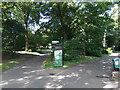
Information board in Bedwellty Park, Tredegar
Located near this entrance. http://www.geograph.org.uk/photo/3639143
Image: © Jaggery
Taken: 5 Sep 2013
0.04 miles
5
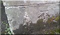
Ordnance Survey Cut Mark
This OS cut mark can be found on the gatepost of the Promenade Gate of Bedwellty Park. It marks a point 288.173m above mean sea level.
Image: © Adrian Dust
Taken: 27 Aug 2018
0.05 miles
6
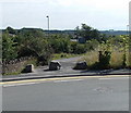
Boulders across a path from Stable Lane, Tredegar
Viewed across Stable Lane. Three boulders prevent cars or lorries using the path.
Image: © Jaggery
Taken: 5 Sep 2013
0.05 miles
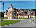
7
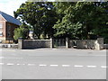
SE entrance to Bedwellty Park and House, Tredegar
Viewed across Stable Lane. A plaque on the wall records that the park was the gift of the Right Honourable Lord Tredegar to the inhabitants of the Urban District of Tredegar
and was publicly opened by his lordship on Thursday the 18th day of April 1901.
Image: © Jaggery
Taken: 5 Sep 2013
0.06 miles
8
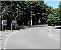
Left turn for the Cholera Cemetery, Tredegar
A sign alongside the B4256 points left towards the Register Office, Leisure Centre and Cholera Cemetery. The cemetery is some distance away, located in Cefn Golau. http://www.geograph.org.uk/photo/498760
One of the first outbreaks of cholera, known as the King of Terrors, in Tredegar occurred in the early 1830s. The generally unsanitary conditions in houses (here and elsewhere in the UK) led to a rapid spread of the disease, which is transmitted primarily by drinking water or eating food that has been contaminated by the faeces of an infected person. Tredegar residents buried their dead as far away from the town as possible, hoping that out of sight meant out of mind.
Housing conditions were very bad, without ventilation or drainage. The gaps between houses were unpaved, often following the lines of the streams serving as conduits for excrement. In 1849 Wales experienced its worst cholera outbreak. In Merthyr Tydfil 1,682 people died of cholera, 1 in 50 of the town's population. In Tredegar the death toll from this outbreak was 203. Scarcely a street in the town was unaffected. The last outbreak of cholera here was in 1866.
Image: © Jaggery
Taken: 5 Sep 2013
0.07 miles
9
Stable Lane, Tredegar
Looking north towards the B4256, past St James Parade http://www.geograph.org.uk/photo/3639056 on the left.
Image: © Jaggery
Taken: 5 Sep 2013
0.07 miles
10
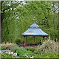
Bandstand, Bedwellty Park, Tredegar
Built in 1912
Grade II listed.
Image: © Robin Drayton
Taken: 29 May 2013
0.09 miles