IMAGES TAKEN NEAR TO
Bill Harry Court, Charles Street, TREDEGAR, NP22 4BA
Introduction
This page details the photographs taken nearby to Bill Harry Court, Charles Street, NP22 4BA by members of the Geograph project.
The Geograph project started in 2005 with the aim of publishing, organising and preserving representative images for every square kilometre of Great Britain, Ireland and the Isle of Man.

There are currently over 7.5m images from over14,400 individuals and you can help contribute to the project by visiting https://www.geograph.org.uk
Image Map
Images are licensed for reuse under creativecommons.org/licenses/by-sa/2.0
Notes
- Clicking on the map will re-center to the selected point.
- The higher the marker number, the further away the image location is from the centre of the postcode.
Image Listing (100 Images Found)
Images are licensed for reuse under creativecommons.org/licenses/by-sa/2.0
Image
Details
Distance
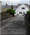
1
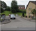
Side road past the edge of Bill Harry Court, Tredegar
Viewed across Charles Street. Bill Harry Court https://www.geograph.org.uk/photo/6234131 is on the right.
Image: © Jaggery
Taken: 7 Aug 2019
0.01 miles
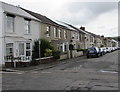
2
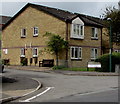
Bill Harry Court, Charles Street, Tredegar
Managed by Linc-Cymru Housing Association, Bill Harry Court is retirement housing containing 40 flats.
Image: © Jaggery
Taken: 7 Aug 2019
0.02 miles
3
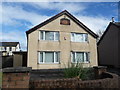
Converted chapel on Charles Street, Tredegar
Welsh speaking Calvinistic Methodist chapel on Nye Bevans home street. Now a residence by the look of things.
Image: © Jeremy Bolwell
Taken: 13 Oct 2012
0.02 miles
4
National Cycle Network route 467 direction sign, Charles Street, Tredegar
The small sign on a wooden pole points along this https://www.geograph.org.uk/photo/6234038 side street.
Image: © Jaggery
Taken: 7 Aug 2019
0.03 miles
5
Side street on the SW side of Charles Street, Tredegar
A nearby sign https://www.geograph.org.uk/photo/6234048 shows that this street is part of National Cycle Network route 467.
Image: © Jaggery
Taken: 7 Aug 2019
0.03 miles
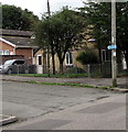
6
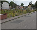
Fenced-off waste ground, Charles Street, Tredegar
In August 2019 temporary fencing extends for 30 metres alongside Charles Street.
An August 2011 Google Street view shows unfenced waste ground here.
Image: © Jaggery
Taken: 7 Aug 2019
0.04 miles
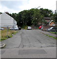
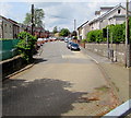
7
Side road from Charles Street to Arnold Place, Tredegar
Patched road surface in August 2019.
Image: © Jaggery
Taken: 7 Aug 2019
0.04 miles
8
On-street parking, Arnold Place, Tredegar
Arnold Place is between Charles Street and the A4048. The road ahead is a dead end.
Image: © Jaggery
Taken: 7 Aug 2019
0.05 miles
9

Recently-built brick houses, Charles Street, Tredegar
Viewed in August 2019. An August 2011 Google Street View shows waste ground here.
Image: © Jaggery
Taken: 7 Aug 2019
0.06 miles
10
West along Charles Street, Tredegar
From the corner of Church Street.
Image: © Jaggery
Taken: 1 Jun 2017
0.06 miles