IMAGES TAKEN NEAR TO
Gainsborough Road, TREDEGAR, NP22 3TG
Introduction
This page details the photographs taken nearby to Gainsborough Road, NP22 3TG by members of the Geograph project.
The Geograph project started in 2005 with the aim of publishing, organising and preserving representative images for every square kilometre of Great Britain, Ireland and the Isle of Man.

There are currently over 7.5m images from over14,400 individuals and you can help contribute to the project by visiting https://www.geograph.org.uk
Image Map
Images are licensed for reuse under creativecommons.org/licenses/by-sa/2.0
Notes
- Clicking on the map will re-center to the selected point.
- The higher the marker number, the further away the image location is from the centre of the postcode.
Image Listing (5 Images Found)
Images are licensed for reuse under creativecommons.org/licenses/by-sa/2.0
Image
Details
Distance
1
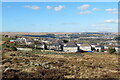
Ystad Cefn Golau / Cefn Golau Estate
Ystad Cefn Golau yn ffinio â'r mynydd.
Cefn Golau Estate borders the mountain.
Image: © Alan Richards
Taken: 18 Mar 2022
0.13 miles
2
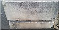
Ordnance Survey Cut Mark
This OS cut mark can be found at the junction of Park Hill & Inkerman Terrace. It marks a point 335.713m above mean sea level.
Image: © Adrian Dust
Taken: 27 Aug 2018
0.22 miles
3
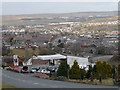
View over Tredegar (2008)
Looking down Park Hill near Cefn Golau and over the town of Tredegar.
For the same view five years later see http://www.geograph.org.uk/photo/3710487
.
Image: © Robin Drayton
Taken: 12 Mar 2008
0.24 miles
4
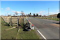
Grid Gwartheg ar y B4256 / Cattle grid on the B4256
Grid gwartheg ar y B4256 ger Cefn Golau.
A cattle grid on the B4256 near Cefn Golau (trans. light ridge).
Image: © Alan Richards
Taken: 18 Mar 2022
0.25 miles
5
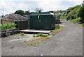
Park Hill electricity substation, Tredegar
The dark green cabinet is a Western Power Distribution electricity substation, identifier PARK HILL TREDEGAR S/S No. 55-1452. It is located alongside a side road above the B4256 Park Hill.
Image: © Jaggery
Taken: 23 May 2017
0.25 miles