IMAGES TAKEN NEAR TO
West Hill, TREDEGAR, NP22 3QZ
Introduction
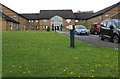
This page details the photographs taken nearby to West Hill, NP22 3QZ by members of the Geograph project.
The Geograph project started in 2005 with the aim of publishing, organising and preserving representative images for every square kilometre of Great Britain, Ireland and the Isle of Man.

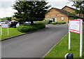
There are currently over 7.5m images from over14,400 individuals and you can help contribute to the project by visiting https://www.geograph.org.uk
Image Map (Loading...)


Getting Data...Please wait
Leaflet Map data © OpenStreetMap
Images are licensed for reuse under creativecommons.org/licenses/by-sa/2.0
Notes
- Clicking on the map will re-center to the selected point.
- The higher the marker number, the further away the image location is from the centre of the postcode.
Image Listing (156 Images Found)
Images are licensed for reuse under creativecommons.org/licenses/by-sa/2.0
Image
Details
Distance
1
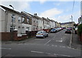
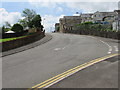
Bournville Terrace, Tredegar
Ascending from Earl Street towards West Hill.
Image: © Jaggery
Taken: 1 Jun 2017
0.02 miles
2
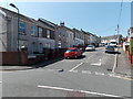
Bournville Terrace, Tredegar
Viewed across Earl Street.
Image: © Jaggery
Taken: 22 Aug 2013
0.02 miles
3
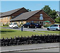
Ty Scott, Tredegar
Viewed across Earl Street. Managed by Linc-Cymru Housing Association, Ty Scott
contains 37 1-bedroom flats, built in 1988. New residents must be at least 55 years old.
Image: © Jaggery
Taken: 22 Aug 2013
0.04 miles
4
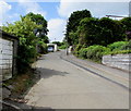
Western end of Gelli Road, Tredegar
Gelli Road ascends from the Earl Street junction.
Image: © Jaggery
Taken: 1 Jun 2017
0.04 miles
5
Entrance to Ty Scott, Tredegar
From Earl Street opposite Aneurin Rise. Managed by Linc-Cymru Housing Association, Ty Scott
contains 37 1-bedroom flats, built in 1988. New residents must be at least 55 years old.
Image: © Jaggery
Taken: 1 Jun 2017
0.05 miles
6
East side of Ty Scott, Tredegar
Viewed from Earl Street. Managed by Linc-Cymru Housing Association, Ty Scott
contains 37 1-bedroom flats, built in 1988. New residents must be at least 55 years old.
Image: © Jaggery
Taken: 1 Jun 2017
0.05 miles
7
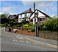
Houses above Gelli Road, Tredegar
Viewed from the corner of Earl Street.
Image: © Jaggery
Taken: 1 Jun 2017
0.06 miles
8
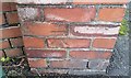
Ordnance Survey Cut Mark
This OS cut mark can be found on the wall of No27 Bournville Terrace. It marks a point 340.446m above mean sea level.
Image: © Adrian Dust
Taken: 27 Aug 2018
0.06 miles
9
Up Earl Street, Tredegar
Earl Street ascends away from Gelli Road.
Image: © Jaggery
Taken: 1 Jun 2017
0.06 miles
10
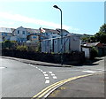
Converted railway wagon body used as a shed, Tredegar
Old railway wagon bodies used for storage can be seen in many rural locations in the UK, less commonly in towns. This one is on the corner of Gelli Road and Earl Street in Tredegar.
Image: © Jaggery
Taken: 22 Aug 2013
0.07 miles