IMAGES TAKEN NEAR TO
Morgan Street, TREDEGAR, NP22 3LX
Introduction
This page details the photographs taken nearby to Morgan Street, NP22 3LX by members of the Geograph project.
The Geograph project started in 2005 with the aim of publishing, organising and preserving representative images for every square kilometre of Great Britain, Ireland and the Isle of Man.

There are currently over 7.5m images from over14,400 individuals and you can help contribute to the project by visiting https://www.geograph.org.uk
Image Map
Images are licensed for reuse under creativecommons.org/licenses/by-sa/2.0
Notes
- Clicking on the map will re-center to the selected point.
- The higher the marker number, the further away the image location is from the centre of the postcode.
Image Listing (266 Images Found)
Images are licensed for reuse under creativecommons.org/licenses/by-sa/2.0
Image
Details
Distance
1
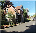
Park Lodge, Tredegar
Located at the town centre (Morgan Street) entrance to Bedwellty Park.
Image: © Jaggery
Taken: 5 Sep 2013
0.00 miles
2
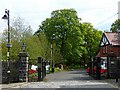
Entrance to Bedwellty Park, Tredegar
Originally the home of the ironmasters of the Tredegar Iron Company.
When the company closed Lord Tredegar made a free gift of the park and
house to the people of Tredegar and it was opened to the public in 1901.
Image: © Robin Drayton
Taken: 29 May 2013
0.00 miles
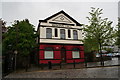
4
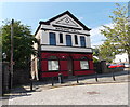
Two-tone Masonic Hall, Tredegar
Viewed across Morgan Street. The hall has been repainted since this http://www.geograph.org.uk/photo/1821646 view in April 2010.
Image: © Jaggery
Taken: 5 Sep 2013
0.01 miles
6
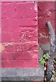
Ordnance Survey Cut Mark
This damaged OS cut mark can be found on the front of the Masonic Hall. It marks a point 992.53ft above mean sea level.
Image: © Adrian Dust
Taken: 27 Aug 2018
0.02 miles
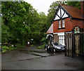
7
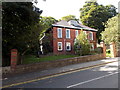
Bedwellty Park Residential Home, Tredegar
Viewed across Morgan Street. Privately-owned Bedwellty Park Residential Home provides long-term and short-term care and also respite care for up to 14 residents.
Image: © Jaggery
Taken: 5 Sep 2013
0.02 miles
8
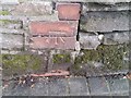
Ordnance Survey Cut Mark
This OS cut mark can be found on the Park Wall SW side of Morgan Street. It marks a point 295.470m above mean sea level.
Image: © Adrian Dust
Taken: 27 Aug 2018
0.03 miles
9
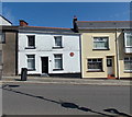
Former residence of Michael Foot in Morgan Street, Tredegar
A reddish brown plaque on the wall of the white house records that Michael Foot lived here. It does not record when. The snippets of information about Michael Foot on the plaque are that he was Labour MP for Ebbw Vale from 1960 to 1983 and for Blaenau Gwent from 1983 to 1992 and that he was the biographer of Aneurin Bevan (who was the founder of the National Health Service and Tredegar's most famous son). There was no room, it seems, to record that he was leader of the Labour Party, nor the year of his birth (1913) and death (2010).
Image: © Jaggery
Taken: 5 Sep 2013
0.04 miles
10
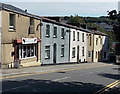
M & L Motorcycles, Tredegar
Motorbike sales, spares, service and repairs shop at 19 Morgan Street, viewed looking away from the town centre.
Image: © Jaggery
Taken: 5 Sep 2013
0.04 miles