IMAGES TAKEN NEAR TO
Kimberley Terrace, TREDEGAR, NP22 3LF
Introduction
This page details the photographs taken nearby to Kimberley Terrace, NP22 3LF by members of the Geograph project.
The Geograph project started in 2005 with the aim of publishing, organising and preserving representative images for every square kilometre of Great Britain, Ireland and the Isle of Man.

There are currently over 7.5m images from over14,400 individuals and you can help contribute to the project by visiting https://www.geograph.org.uk
Image Map
Images are licensed for reuse under creativecommons.org/licenses/by-sa/2.0
Notes
- Clicking on the map will re-center to the selected point.
- The higher the marker number, the further away the image location is from the centre of the postcode.
Image Listing (90 Images Found)
Images are licensed for reuse under creativecommons.org/licenses/by-sa/2.0
Image
Details
Distance
1
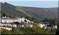
Hillside houses, Georgetown
A view from the centre of Tredegar across the Sirhowy Valley.
This is the view to the right of that shown here http://www.geograph.org.uk/photo/3716726 .
Image: © Robin Drayton
Taken: 23 Oct 2013
0.04 miles
2
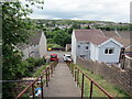
Llwybr i Deras Fictoria / Path to Victoria Terrace
Stepiau yn arwain lawr at Deras Fictoria.
Steps leading down to Victoria Terrace.
Image: © Alan Richards
Taken: 22 May 2022
0.06 miles
3
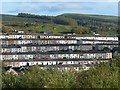
Terraced housing, Georgetown
A view from the centre of Tredegar across the Sirhowy Valley.
Image: © Robin Drayton
Taken: 23 Oct 2013
0.07 miles
4
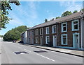
Park Place houses, Georgetown, Tredegar
The houses in this part of Park Place face a fence and trees lining the east bank of the Sirhowy River.
Image: © Jaggery
Taken: 5 Sep 2013
0.09 miles
5
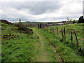
Llwybr i Deras Mafeking / Path to Mafeking Terrace
Llwybr cyhoeddus yn mynd i gyfeiriad Teras Mafeking.
A public footpath heading towards Mafeking Terrace.
Image: © Alan Richards
Taken: 22 May 2022
0.12 miles
6
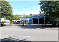
Parker Motors Garage, Tredegar
Garage and MoT test centre, viewed across the B4256 Promenade d'Orvault.
Image: © Jaggery
Taken: 5 Sep 2013
0.12 miles
7
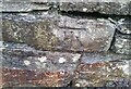
Ordnance Survey Cut Mark
This OS cut mark can be found on the wall north side of Georgetown Hill. It marks a point 327.110m above mean sea level.
Image: © Adrian Dust
Taken: 5 Dec 2020
0.13 miles
8
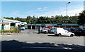
Promenade Motor Company, Tredegar
Used car business, servicing, tyres, MoTs etc, viewed across the B4256 Promenade d'Orvault.
Image: © Jaggery
Taken: 5 Sep 2013
0.14 miles
9
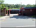
Royal Mail Delivery Office, Tredegar
Viewed across Promenade d'Orvault, Tredegar.
Image: © Jaggery
Taken: 5 Sep 2013
0.14 miles
10
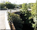
Road bridge over the Sirhowy, Tredegar
View from Park Place. The river here flows on the east side of the A4048.
Image: © Jaggery
Taken: 5 Sep 2013
0.15 miles