IMAGES TAKEN NEAR TO
Lower Coronation Street, TREDEGAR, NP22 3JE
Introduction
This page details the photographs taken nearby to Lower Coronation Street, NP22 3JE by members of the Geograph project.
The Geograph project started in 2005 with the aim of publishing, organising and preserving representative images for every square kilometre of Great Britain, Ireland and the Isle of Man.

There are currently over 7.5m images from over14,400 individuals and you can help contribute to the project by visiting https://www.geograph.org.uk
Image Map
Images are licensed for reuse under creativecommons.org/licenses/by-sa/2.0
Notes
- Clicking on the map will re-center to the selected point.
- The higher the marker number, the further away the image location is from the centre of the postcode.
Image Listing (273 Images Found)
Images are licensed for reuse under creativecommons.org/licenses/by-sa/2.0
Image
Details
Distance
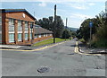
1
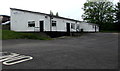
Moose Hall in Tredegar
Moose International Tredegar Number 1 lodge is located in Moose Hall set back
from Lower Coronation Street. Private car park - members and guests only.
Image: © Jaggery
Taken: 23 May 2017
0.01 miles
2
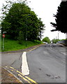
Iron Row, Tredegar
Iron Row ascends from the corner of Shop Row and Bridge Street.
Image: © Jaggery
Taken: 23 May 2017
0.03 miles
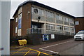
4
Tredegar Police Station
Part of Gwent Police force, the station is in Spencer Square, on the corner of Iron Street and Iron Row.
Tredegar Magistrates Court http://www.geograph.org.uk/photo/1821704 is out of shot on the right.
Image: © Jaggery
Taken: 5 Sep 2013
0.03 miles
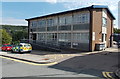
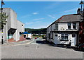
5
Lower Coronation Street, Tredegar
Looking SE from Coronation Street. The Magistrates Court http://www.geograph.org.uk/photo/1821704 is on the left.
Image: © Jaggery
Taken: 5 Sep 2013
0.04 miles
6
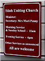
Siloh Uniting Church information board, Tredegar
Facing Bridge Street here. http://www.geograph.org.uk/photo/5403016
Image: © Jaggery
Taken: 23 May 2017
0.04 miles
7
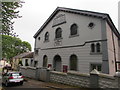
North side of Siloh Uniting Church in Tredegar
The old name of the church, SILOH BAPTIST CHURCH, remains in place in 2017.
Siloh Uniting Church, the church's current name, is displayed at the entrance. http://www.geograph.org.uk/photo/5403019
Image: © Jaggery
Taken: 23 May 2017
0.04 miles
8
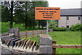
Officialese on a Tredegar corner
The Borough of Blaenau Gwent notice on the corner of Bridge Street and Lower Coronation Street is an example of officialese. Presumably 'strictly' is included for emphasis. Is anything ever casually prohibited?
Image: © Jaggery
Taken: 23 May 2017
0.04 miles
9
Iron Street, Tredegar
Looking NE from The Circle along Iron Street towards Iron Row.
Tredegar Library http://www.geograph.org.uk/photo/1821627 is on the left.
Made in Tredegar Community Film Studio is on the right. http://www.geograph.org.uk/photo/3640667
Image: © Jaggery
Taken: 5 Sep 2013
0.04 miles
10

Siloh Uniting Church in Tredegar
Viewed across Bridge Street in May 2017 when the nameboard http://www.geograph.org.uk/photo/5403019 shows Siloh Uniting Church.
SILOH BAPTIST CHURCH and BUILT 1806 are on the front of building. http://www.geograph.org.uk/photo/5403023
The Coflein website states that Siloh Baptist Chapel was built in 1763, rebuilt in 1806, modified in 1820 and again in 1839. The last rebuild took place in 1905 in the Sub-Classical and Arts and Craft style with a gable entry plan and two storeys.
Image: © Jaggery
Taken: 23 May 2017
0.04 miles