IMAGES TAKEN NEAR TO
Martindale Close, TREDEGAR, NP22 3HX
Introduction
This page details the photographs taken nearby to Martindale Close, NP22 3HX by members of the Geograph project.
The Geograph project started in 2005 with the aim of publishing, organising and preserving representative images for every square kilometre of Great Britain, Ireland and the Isle of Man.

There are currently over 7.5m images from over14,400 individuals and you can help contribute to the project by visiting https://www.geograph.org.uk
Image Map (Loading...)


Getting Data...Please wait
Leaflet Map data © OpenStreetMap
Images are licensed for reuse under creativecommons.org/licenses/by-sa/2.0
Notes
- Clicking on the map will re-center to the selected point.
- The higher the marker number, the further away the image location is from the centre of the postcode.
Image Listing (86 Images Found)
Images are licensed for reuse under creativecommons.org/licenses/by-sa/2.0
Image
Details
Distance
1

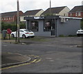
Martindale Close, Tredegar
Viewed across Sycamore Avenue.
Image: © Jaggery
Taken: 22 Aug 2013
0.02 miles
2
Hair Play, Charles Street, Tredegar
Hair salon viewed in August 2019. A Ladrokes betting shop was here in an October 2009 Google Street View.
Image: © Jaggery
Taken: 7 Aug 2019
0.04 miles
3
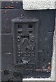
Ordnance Survey Flush Bracket (S1222)
This OS Flush Bracket can be found on the Coach & Horses, Charles Street. It marks a point 321.056m above mean sea level.
Image: © Adrian Dust
Taken: 13 Jun 2020
0.04 miles
4
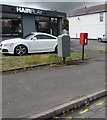
Queen Elizabeth II postbox and Royal Mail drop box, Charles Street, Tredegar
On the left here. https://www.geograph.org.uk/photo/6231710
Image: © Jaggery
Taken: 7 Aug 2019
0.04 miles
5
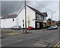
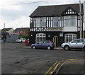
Coach & Horses in Tredegar
Charles Street pub with bed & breakfast accommodation. https://www.geograph.org.uk/photo/6231695 to the name sign.
Image: © Jaggery
Taken: 7 Aug 2019
0.04 miles
6
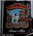
Coach & Horses name sign, Charles Street, Tredegar
Hanging from a wall bracket here. https://www.geograph.org.uk/photo/6231651
Image: © Jaggery
Taken: 7 Aug 2019
0.04 miles
7
North side of the Coach & Horses, Charles Street, Tredegar
Pub with bed & breakfast accommodation viewed from Arnold Place. https://www.geograph.org.uk/photo/6231651 to another view.
Image: © Jaggery
Taken: 7 Aug 2019
0.04 miles
8
Charles Street flats, Tredegar
Located near the Coach & Horses. https://www.geograph.org.uk/photo/6231651
Image: © Jaggery
Taken: 7 Aug 2019
0.05 miles
9

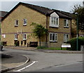
United Way, Tredegar
Viewed across Stockton Way. United Way is a cul-de-sac of houses built in the early 21st century.
Image: © Jaggery
Taken: 22 Aug 2013
0.05 miles
10
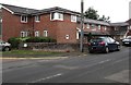
Bill Harry Court, Charles Street, Tredegar
Managed by Linc-Cymru Housing Association, Bill Harry Court is retirement housing containing 40 flats.
Image: © Jaggery
Taken: 7 Aug 2019
0.07 miles