IMAGES TAKEN NEAR TO
Church Street, TREDEGAR, NP22 3DU
Introduction
This page details the photographs taken nearby to Church Street, NP22 3DU by members of the Geograph project.
The Geograph project started in 2005 with the aim of publishing, organising and preserving representative images for every square kilometre of Great Britain, Ireland and the Isle of Man.

There are currently over 7.5m images from over14,400 individuals and you can help contribute to the project by visiting https://www.geograph.org.uk
Image Map
Images are licensed for reuse under creativecommons.org/licenses/by-sa/2.0
Notes
- Clicking on the map will re-center to the selected point.
- The higher the marker number, the further away the image location is from the centre of the postcode.
Image Listing (138 Images Found)
Images are licensed for reuse under creativecommons.org/licenses/by-sa/2.0
Image
Details
Distance
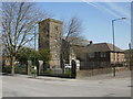
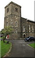
1
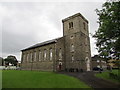
Grade II listed St George's Church, Tredegar
The church set back from the east side of Church Street is part of the Church in Wales Diocese of Monmouth. Cadw records that the church was built in 1835-1836 to the designs of London architect John Jenkins. The church was required to serve the rapidly-growing ironworks town. It was designed in the neo-Norman style which was briefly popular for church architecture in the 1830s and 1840s. The building was Grade II Listed in 1999.
Image: © Jaggery
Taken: 7 Aug 2019
0.03 miles
2
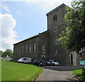
North side of St George's Church, Tredegar
Viewed from Church Street. The church is part of the Church in Wales Diocese of Monmouth.
It was built in 1835-1836 to serve the rapidly growing ironworks town of Tredegar. It was designed in the neo-Norman style which was briefly popular for church architecture in the 1830s and 1840s.
The building was Grade II listed in 1999.
Image: © Jaggery
Taken: 1 Jun 2017
0.03 miles
3
St George's Church and Vicarage, Tredegar
Viewed across Church Street. http://www.geograph.org.uk/photo/5414022 to a view of the north side of
the Grade II listed church in the Church in Wales Diocese of Monmouth.
Image: © Jaggery
Taken: 1 Jun 2017
0.04 miles
4
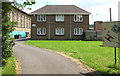
St George's Vicarage, Tredegar
Located on the south side of St George's church, on the right here. http://www.geograph.org.uk/photo/5414034
Image: © Jaggery
Taken: 1 Jun 2017
0.04 miles
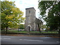
5
St George's Church, Tredegar
St George's Parish Church, located on Church Street, is a stone, rectangular building in the Norman style. The church register dates from 1836.
The Church in Wales, Diocese of Monmouth, church is Grade II listed.
Image: © Jaggery
Taken: 21 Apr 2010
0.04 miles
6
Church in Tredegar
A church amongst many chapels in its day I expect.
Image: © Jeremy Bolwell
Taken: 13 Oct 2012
0.04 miles
7
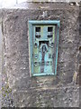
Ordnance Survey Flush Bracket (S1221)
This OS cut mark can be found on the west angle of St George's Church. It marks a point 312.924m above mean sea level.
Image: © Adrian Dust
Taken: 26 Mar 2016
0.04 miles
8

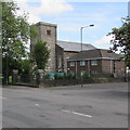
South along Church Street, Tredegar
Looking towards the tower http://www.geograph.org.uk/photo/5414022 of St George's Church 220 metres ahead.
Image: © Jaggery
Taken: 1 Jun 2017
0.04 miles
9
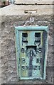
Ordnance Survey Flush Bracket (S1221)
This OS Flush Bracket can be found on the west angle of St George's Church. It marks a point 312.924m above mean sea level. A cancelled OS pivot (1027.7ft) can be seen poking out above.
Image: © Adrian Dust
Taken: 27 Aug 2018
0.04 miles
10
Tower of St George's Church, Tredegar
The church is part of the Church in Wales Diocese of Monmouth. It was built in 1835-1836 to serve the rapidly growing ironworks town of Tredegar. It was designed in the neo-Norman style which was briefly popular for church architecture in the 1830s and 1840s. The building was Grade II listed in 1999.
Image: © Jaggery
Taken: 7 Aug 2019
0.04 miles