IMAGES TAKEN NEAR TO
Church Street, TREDEGAR, NP22 3DT
Introduction
This page details the photographs taken nearby to Church Street, NP22 3DT by members of the Geograph project.
The Geograph project started in 2005 with the aim of publishing, organising and preserving representative images for every square kilometre of Great Britain, Ireland and the Isle of Man.

There are currently over 7.5m images from over14,400 individuals and you can help contribute to the project by visiting https://www.geograph.org.uk
Image Map
Images are licensed for reuse under creativecommons.org/licenses/by-sa/2.0
Notes
- Clicking on the map will re-center to the selected point.
- The higher the marker number, the further away the image location is from the centre of the postcode.
Image Listing (138 Images Found)
Images are licensed for reuse under creativecommons.org/licenses/by-sa/2.0
Image
Details
Distance
1
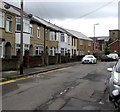
Houses on the east side of Church Street, Tredegar
The tower https://www.geograph.org.uk/photo/6231908 of St George's Church is in the background.
Image: © Jaggery
Taken: 7 Aug 2019
0.02 miles
2

Millennium Wood Floors shop in Tredegar
Flooring shop at 63 Church Street.
Image: © Jaggery
Taken: 1 Jun 2017
0.02 miles
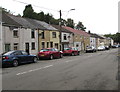
3

West side of Church Street, Tredegar
The name Cartref is conspicuously displayed on the doorway on the left.
Image: © Jaggery
Taken: 1 Jun 2017
0.04 miles
4
On-street parking, Church Street, Tredegar
Cars and houses on the west side of Church Street.
Image: © Jaggery
Taken: 7 Aug 2019
0.04 miles
5
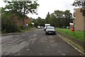
Dead-end road on the NE side of Church Street, Tredegar
Trees in the background are on a bank of the Sirhowy River.
Image: © Jaggery
Taken: 7 Aug 2019
0.05 miles
6

Ashleigh Court, Church Street, Tredegar
The name sign on the wall on the right shows ASHLEIGH COURT NOS (numbers) 1-5.
Numbers 1,2 and 3 are in view.
Image: © Jaggery
Taken: 1 Jun 2017
0.05 miles
7
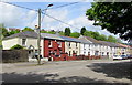
Long row of houses, Church Street, Tredegar
On the west side of Church Street, viewed looking northwards.
Image: © Jaggery
Taken: 1 Jun 2017
0.05 miles
8
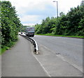
Metal barrier alongside the A4048, Tredegar
The northwest end of a metal barrier extending for 60 metres between the A4048 and the pavement.
Image: © Jaggery
Taken: 1 Jun 2017
0.06 miles
9
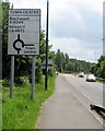
Directions sign on the approach to Town Centre Roundabout, Tredegar
Alongside the A4048.
Image: © Jaggery
Taken: 1 Jun 2017
0.06 miles
10
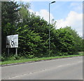
Directions sign on the approach to Sirhowy Roundabout, Tredegar
Viewed across the A4048.
Image: © Jaggery
Taken: 1 Jun 2017
0.07 miles