IMAGES TAKEN NEAR TO
Oliver Jones Crescent, TREDEGAR, NP22 3BJ
Introduction
This page details the photographs taken nearby to Oliver Jones Crescent, NP22 3BJ by members of the Geograph project.
The Geograph project started in 2005 with the aim of publishing, organising and preserving representative images for every square kilometre of Great Britain, Ireland and the Isle of Man.

There are currently over 7.5m images from over14,400 individuals and you can help contribute to the project by visiting https://www.geograph.org.uk
Image Map
Images are licensed for reuse under creativecommons.org/licenses/by-sa/2.0
Notes
- Clicking on the map will re-center to the selected point.
- The higher the marker number, the further away the image location is from the centre of the postcode.
Image Listing (208 Images Found)
Images are licensed for reuse under creativecommons.org/licenses/by-sa/2.0
Image
Details
Distance
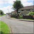
1
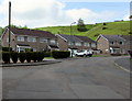
Oliver Jones Crescent houses, Tredegar
Oliver Jones Crescent is at the western edge of residential Tredegar.
Image: © Jaggery
Taken: 1 Jun 2017
0.02 miles
2

Oliver Jones Crescent, Tredegar
Oliver Jones Crescent is at the western edge of residential Tredegar.
The road here is 340 metres (1,115ft) above mean sea level.
Image: © Jaggery
Taken: 1 Jun 2017
0.02 miles
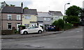
3
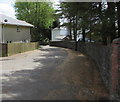
Union Street, Tredegar
Union Street descends away from Oliver Jones Crescent.
Image: © Jaggery
Taken: 1 Jun 2017
0.03 miles
4
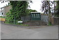
Lloyds Field electricity substation, Tredegar
Located at the edge of Oliver Jones Crescent, the dark green cabinet is a Western Power
Distribution electricity substation. Its identifier is LLOYDS FIELD TREDEGAR S/S 551420
Image: © Jaggery
Taken: 1 Jun 2017
0.03 miles
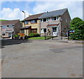
5
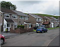
West side of Oliver Jones Crescent, Tredegar
Oliver Jones Crescent is at the western edge of residential Tredegar.
Image: © Jaggery
Taken: 1 Jun 2017
0.05 miles
6
Southern arm of Oliver Jones Crescent, Tredegar
Viewed from the corner of the main part of Oliver Jones Crescent at the western edge of residential Tredegar.
Image: © Jaggery
Taken: 1 Jun 2017
0.05 miles
7
Union Street houses opposite Earl Street, Tredegar
Behind the white car, a street name sign shows UNION STREET 33A TO 35.
Image: © Jaggery
Taken: 1 Jun 2017
0.05 miles
8
Houses at the northern end of Oliver Jones Crescent, Tredegar
Oliver Jones Crescent is at the western edge of residential Tredegar.
Image: © Jaggery
Taken: 1 Jun 2017
0.05 miles
9
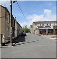
Up Glandovey Terrace, Tredegar
Ascending towards West Hill and Western Crescent.
Image: © Jaggery
Taken: 1 Jun 2017
0.06 miles
10
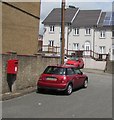
Queen Elizabeth II postbox on a Tredegar corner
Near the Glandovey Terrace junction and a row of 21st century houses. http://www.geograph.org.uk/photo/5421957
Image: © Jaggery
Taken: 1 Jun 2017
0.07 miles