IMAGES TAKEN NEAR TO
Nantybwch, TREDEGAR, NP22 3BB
Introduction
This page details the photographs taken nearby to NP22 3BB by members of the Geograph project.
The Geograph project started in 2005 with the aim of publishing, organising and preserving representative images for every square kilometre of Great Britain, Ireland and the Isle of Man.

There are currently over 7.5m images from over14,400 individuals and you can help contribute to the project by visiting https://www.geograph.org.uk
Image Map
Images are licensed for reuse under creativecommons.org/licenses/by-sa/2.0
Notes
- Clicking on the map will re-center to the selected point.
- The higher the marker number, the further away the image location is from the centre of the postcode.
Image Listing (44 Images Found)
Images are licensed for reuse under creativecommons.org/licenses/by-sa/2.0
Image
Details
Distance
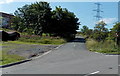
1
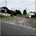
Side road, Waundeg, Tredegar
The road diverges from the road named Waundeg in the Waundeg area of Tredegar.
The road near the camera is 375 metres (1,230 ft) above mean sea level.
Image: © Jaggery
Taken: 17 Jul 2019
0.09 miles
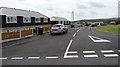
2
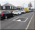
Waundeg speed bumps, Tredegar
Speed bumps/humps across the road named Waundeg in the Waundeg area of Tredegar.
Image: © Jaggery
Taken: 17 Jul 2019
0.10 miles
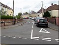
3

One-way signs, Waundeg, Tredegar
Alongside the road named Waundeg in the Waundeg area of Tredegar.
Image: © Jaggery
Taken: 17 Jul 2019
0.11 miles
4
Tynewydd, Tredegar
Looking to the NW along Tynewydd from Waundeg.
These roads with Welsh names do not have an English name.
Image: © Jaggery
Taken: 17 Jul 2019
0.14 miles
6
Tynewydd, Nant-y-Bwch
Viewed across Trefil Road. Tynewydd is the name of the road ahead and the area through which it passes.
Image: © Jaggery
Taken: 22 Aug 2013
0.16 miles
7
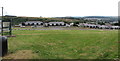
Waundeg houses opposite a green, Tredegar
Alongside the road named Waundeg in the Waundeg area of Tredegar.
Image: © Jaggery
Taken: 17 Jul 2019
0.18 miles
8
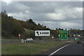
A4048 Slip Road onto Nantybwch Roundabout
A465>A4048 Slip road leading onto the Nantybwch roundabout, in Tredegar.
Image: © Luke Jones
Taken: 16 Oct 2022
0.19 miles
9
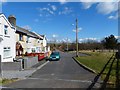
Railway Cottages, Nantybwch
Nantybwch station used to be opposite these cottages.
This was on the Merthyr, Tredegar and Abergavenny Railway; this section commonly referred to as the Heads of the Valleys Railway.
The last passenger train ran on 5th January 1958.
The station was also the end of the Sirhowy Valley line.
The altitude here is 350 metres and in his book “Lost Railways of South Wales” Mike Hall says “Another bleak unforgiving place, its open-lattice footbridge with no added protection from the elements was not the place to linger on a cold day.”
National Cycle Route 46 passes these cottages.
Image: © Robin Drayton
Taken: 14 Mar 2013
0.19 miles
10
Houses behind a green, Waundeg, Tredegar
Viewed from the road named Waundeg in the Waundeg area of Tredegar.
Image: © Jaggery
Taken: 17 Jul 2019
0.19 miles