IMAGES TAKEN NEAR TO
Merthyr Road, TREDEGAR, NP22 3AY
Introduction
This page details the photographs taken nearby to Merthyr Road, NP22 3AY by members of the Geograph project.
The Geograph project started in 2005 with the aim of publishing, organising and preserving representative images for every square kilometre of Great Britain, Ireland and the Isle of Man.

There are currently over 7.5m images from over14,400 individuals and you can help contribute to the project by visiting https://www.geograph.org.uk
Image Map
Images are licensed for reuse under creativecommons.org/licenses/by-sa/2.0
Notes
- Clicking on the map will re-center to the selected point.
- The higher the marker number, the further away the image location is from the centre of the postcode.
Image Listing (81 Images Found)
Images are licensed for reuse under creativecommons.org/licenses/by-sa/2.0
Image
Details
Distance
1
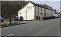
Plymouth Arms Cottages, Merthyr Road, Tafarnaubach
The former Plymouth Arms pub converted to cottages.
Image: © Jaggery
Taken: 15 Apr 2019
0.01 miles
2
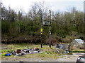
Line spur pole near Plymouth Arms Cottages, Tafarnaubach
Part of Western Power Distribution's electricity supply infrastructure located on the left here. https://www.geograph.org.uk/photo/6122629
Image: © Jaggery
Taken: 15 Apr 2019
0.01 miles
3
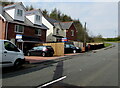
New houses, Merthyr Road, Tafarnaubach
Recently-built houses viewed in April 2019.
Image: © Jaggery
Taken: 15 Apr 2019
0.03 miles
4
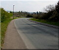
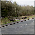
Bend in Merthyr Road, Tafarnaubach
The road near the camera is about 365 metres (almost 1,200 ft) above mean sea level.
Ahead for the centre of Tredegar.
Image: © Jaggery
Taken: 15 Apr 2019
0.04 miles
5
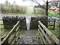
Wall-gap and footbridge on the edge of Parc Brynbach
A bit of a squeeze with even just a daysack on.
Image: © Jeremy Bolwell
Taken: 13 Oct 2012
0.04 miles
6
Wooden bridge in Tafarnaubach
From Merthyr Road, the bridge over a brook leads to the northern edge of Parc Bryn Bach/Bryn Bach Park.
Image: © Jaggery
Taken: 15 Apr 2019
0.04 miles
7
Into Parc Bryn Bach/Bryn Bach Park, Tafarnaubach
From Merthyr Road, the bridge https://www.geograph.org.uk/photo/6122643 over a brook leads to the northern edge of the park.
Image: © Jaggery
Taken: 15 Apr 2019
0.04 miles
8
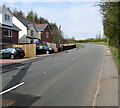
Towards a bend in Merthyr Road, Tafarnaubach
The road here is about 360 metres (c1,180 ft) above mean sea level.
Image: © Jaggery
Taken: 15 Apr 2019
0.04 miles
9
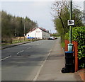
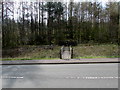
Speed camera warning sign in Tafarnaubach
Facing westbound traffic on Merthyr Road.
Image: © Jaggery
Taken: 15 Apr 2019
0.06 miles
10
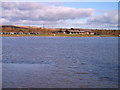
Bryn Bach Park lake and visitor centre
Bryn Bach park lake is a flooded open cast mine near Tredegar now used as a country park with model boat racing, fishing wind surfing and a campsite
Image: © nantcoly
Taken: 13 Nov 2005
0.06 miles