IMAGES TAKEN NEAR TO
Bettws Close, NEWPORT, NP20 7YA
Introduction
This page details the photographs taken nearby to Bettws Close, NP20 7YA by members of the Geograph project.
The Geograph project started in 2005 with the aim of publishing, organising and preserving representative images for every square kilometre of Great Britain, Ireland and the Isle of Man.

There are currently over 7.5m images from over14,400 individuals and you can help contribute to the project by visiting https://www.geograph.org.uk
Image Map
Images are licensed for reuse under creativecommons.org/licenses/by-sa/2.0
Notes
- Clicking on the map will re-center to the selected point.
- The higher the marker number, the further away the image location is from the centre of the postcode.
Image Listing (181 Images Found)
Images are licensed for reuse under creativecommons.org/licenses/by-sa/2.0
Image
Details
Distance
1
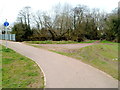
Track to Civil Service Sports Fields, Bettws, Newport
A few metres from the footbridge http://www.geograph.org.uk/photo/2858866 across Malpas Brook, a track on the right heads away from the footpath and cycle way.
Image: © Jaggery
Taken: 21 Mar 2012
0.00 miles
2
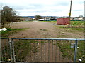
Waste ground, Bettws, Newport
Looking towards houses in Shannon Close on the left and the Civil Service Sports Ground buildings on the right.
Image: © Jaggery
Taken: 21 Mar 2012
0.00 miles
3
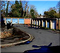
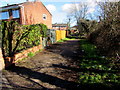
Bettws Close lockup garages, Bettws, Newport
On the south bank of Malpas Brook.
Image: © Jaggery
Taken: 9 Feb 2018
0.01 miles
4
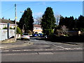
Bettws Close, Bettws, Newport
On the east side of Monnow Way near the Bettws Lane junction.
Image: © Jaggery
Taken: 9 Feb 2018
0.01 miles
5
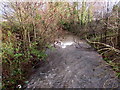
Vigorous Malpas Brook, Bettws, Newport
Malpas Brook flows swiftly away from Monnow Way during a wet period in early January 2016.
Image: © Jaggery
Taken: 5 Jan 2016
0.02 miles
6
Public footpath on the north bank of Malpas Brook, Bettws, Newport
This part of the path is east of Monnow Way, near Shannon Close.
Image: © Jaggery
Taken: 9 Feb 2018
0.03 miles
7
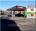
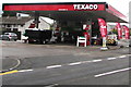
Texaco filling station, Monnow Way, Bettws, Newport
Viewed across speed bumps. A Londis shop is on the right.
Image: © Jaggery
Taken: 9 Feb 2018
0.03 miles
8
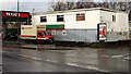
Snacks Direct van outside Londis, Bettws, Newport
Viewed across Monnow Way. The P&H (Palmer & Harvey) van is delivering stock for the Londis store at the back of a Texaco filling station. In early January 2016, the P&H website states:
"Palmer and Harvey is the UK’s number 1 delivered wholesaler, with an annual turnover of more than £4 billion, serving multiple, convenience, forecourt and CTN retail outlets. Since our inception 90 years ago, the company has grown through a mixture of organic growth and targeted acquisitions. Our industry-leading delivery network of 15 regional depots serves over 88,000 UK retail outlets, and places Palmer and Harvey within two hours of each and every customer. A diverse fleet of over 1,000 vehicles makes more than 60,000 deliveries every week, in every UK postcode."
Image: © Jaggery
Taken: 5 Jan 2016
0.04 miles
9
Texaco filling station, Monnow Way, Bettws, Newport
Near the Bettws Lane junction. A small Londis store is in the background.
Image: © Jaggery
Taken: 20 Aug 2018
0.04 miles
10
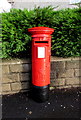
Queen Elizabeth II pillarbox in Bettws, Newport
On the east side of Monnow Way, near the corner of Bettws Close. http://www.geograph.org.uk/photo/4783717
Image: © Jaggery
Taken: 5 Jan 2016
0.04 miles