IMAGES TAKEN NEAR TO
Lambourne Walk, NEWPORT, NP20 7UB
Introduction
This page details the photographs taken nearby to Lambourne Walk, NP20 7UB by members of the Geograph project.
The Geograph project started in 2005 with the aim of publishing, organising and preserving representative images for every square kilometre of Great Britain, Ireland and the Isle of Man.

There are currently over 7.5m images from over14,400 individuals and you can help contribute to the project by visiting https://www.geograph.org.uk
Image Map
Images are licensed for reuse under creativecommons.org/licenses/by-sa/2.0
Notes
- Clicking on the map will re-center to the selected point.
- The higher the marker number, the further away the image location is from the centre of the postcode.
Image Listing (150 Images Found)
Images are licensed for reuse under creativecommons.org/licenses/by-sa/2.0
Image
Details
Distance
1
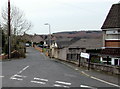
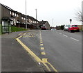
Lambourne Walk, Bettws, Newport
Viewed from Lambourne Crescent. Many of the streets in Bettws are named after British rivers.
The street name sign shows LAMBOURNE, probably an error for LAMBOURN, a river http://www.geograph.org.uk/photo/4426493 in Berkshire.
Image: © Jaggery
Taken: 29 Feb 2016
0.02 miles
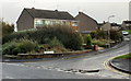
2
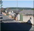
Lambourne Walk, Bettws, Newport
Houses on the NW side of the street, viewed from the Lambourne Crescent end.
Image: © Jaggery
Taken: 28 Apr 2011
0.03 miles
3
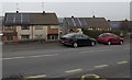
Rooftop solar panels, Monnow Way, Bettws, Newport
Viewed from this bus shelter. http://www.geograph.org.uk/photo/4845032
Image: © Jaggery
Taken: 29 Feb 2016
0.03 miles
4
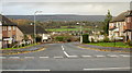
Lambourne Crescent, Bettws, Newport
Viewed from Monnow Way.
Image: © Jaggery
Taken: 7 Nov 2009
0.04 miles
5
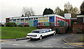
Don Close Nursery School, Bettws, Newport
Viewed from Monnow Way. Located next to the Nursery School, beyond the right edge of the photo, is Bettws Day Nursery.http://www.geograph.org.uk/photo/1574027
Image: © Jaggery
Taken: 7 Nov 2009
0.04 miles
6
Humber Road, Bettws, Newport
Houses on the north side of Humber Road, viewed from Monnow Way.
Image: © Jaggery
Taken: 7 Nov 2009
0.04 miles
7
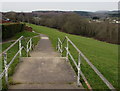
Footpath west from Lambourne Crescent, Bettws, Newport
Towards Monnow Way past the backs of houses in Lambourne Walk.
Image: © Jaggery
Taken: 29 Feb 2016
0.04 miles
8
Lambourne Walk electricity substation, Bettws, Newport
Viewed from Monnow Way, the main road through the Bettws Estate. The large cabinet is a Western Power Distribution electricity substation, identifier LAMBOURNE WALK BETTWS S/S 532129
Image: © Jaggery
Taken: 22 Aug 2018
0.04 miles
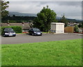
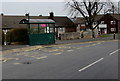
9
Bus stop and shelter alongside bus route 16, Monnow Way, Bettws, Newport
Route 16 is city centre to Bettws via Monnow Way (clockwise) then back to the city centre.
Image: © Jaggery
Taken: 29 Feb 2016
0.04 miles
10
Monnow Way bus stop and shelter near Lambourne Crescent, Bettws, Newport
This stop is on Newport Bus Route 15 (city centre to Bettws via Monnow Way (counterclockwise) then back to the city centre). A nearby stop on the opposite side of the road is part of Route 16 (city centre to Bettws via Monnow Way (clockwise) then back to the city centre).
Image: © Jaggery
Taken: 29 Feb 2016
0.04 miles