IMAGES TAKEN NEAR TO
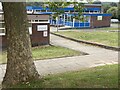
Monnow Way, NEWPORT, NP20 7TD
Introduction
This page details the photographs taken nearby to Monnow Way, NP20 7TD by members of the Geograph project.
The Geograph project started in 2005 with the aim of publishing, organising and preserving representative images for every square kilometre of Great Britain, Ireland and the Isle of Man.

There are currently over 7.5m images from over14,400 individuals and you can help contribute to the project by visiting https://www.geograph.org.uk
Image Map
Images are licensed for reuse under creativecommons.org/licenses/by-sa/2.0
Notes
- Clicking on the map will re-center to the selected point.
- The higher the marker number, the further away the image location is from the centre of the postcode.
Image Listing (157 Images Found)
Images are licensed for reuse under creativecommons.org/licenses/by-sa/2.0
Image
Details
Distance
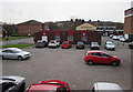
1
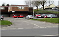
Bettws Health Centre and car park, Newport
Viewed across Lambourne Way near the Monnow Way junction.
Image: © Jaggery
Taken: 29 Feb 2016
0.00 miles
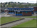
2
East side of Bettws Health Centre, Newport
Lambourne Way side of the health centre at 500 Monnow Way.
Image: © Jaggery
Taken: 20 Aug 2018
0.01 miles
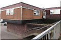
3
Bettws Health Centre, Newport
Located at 500 Monnow Way, set below road level at the northern edge
of an area of shops and public buildings on the west side of Lambourne Way.
Image: © Jaggery
Taken: 29 May 2014
0.01 miles
4
Entrance to Bettws Health Centre, Newport
From the corner of Monnow Way and Lambourne Way.
Image: © Jaggery
Taken: 29 Feb 2016
0.01 miles
5
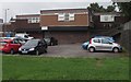
Car park on the corner of Monnow Way and Lambourne Way, Bettws, Newport
On the north side of the Nightingale pub. http://www.geograph.org.uk/photo/4880578
Image: © Jaggery
Taken: 29 Feb 2016
0.02 miles
6
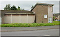
Former Bettws Free Church , Newport
Boarded-up former Bettws Free Church United Reformed building on the corner of Tone Close and Monnow Way. Here's how it looked when in use 2 years previously. http://www.geograph.org.uk/photo/350993
Image: © Jaggery
Taken: 31 Aug 2009
0.02 miles
7
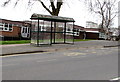
Bus stop and shelter above Bettws Health Centre, Newport
Viewed across Monnow Way. Bettws Health Centre is behind and below the shelter.
Image: © Jaggery
Taken: 29 Feb 2016
0.02 miles
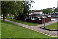
8
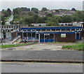
Bettws Library and Information Centre, Newport
Below the south side of Monnow Way, the main road through the Bettws Estate.
Image: © Jaggery
Taken: 20 Aug 2018
0.02 miles
10
Bettws Library and Information Centre, Newport
Part of Newport City Council library service, located in Bettws Shopping Centre, below Monnow Way.
Image: © Jaggery
Taken: 29 May 2014
0.03 miles