IMAGES TAKEN NEAR TO
Monnow Way, NEWPORT, NP20 7RU
Introduction
This page details the photographs taken nearby to Monnow Way, NP20 7RU by members of the Geograph project.
The Geograph project started in 2005 with the aim of publishing, organising and preserving representative images for every square kilometre of Great Britain, Ireland and the Isle of Man.

There are currently over 7.5m images from over14,400 individuals and you can help contribute to the project by visiting https://www.geograph.org.uk
Image Map
Images are licensed for reuse under creativecommons.org/licenses/by-sa/2.0
Notes
- Clicking on the map will re-center to the selected point.
- The higher the marker number, the further away the image location is from the centre of the postcode.
Image Listing (136 Images Found)
Images are licensed for reuse under creativecommons.org/licenses/by-sa/2.0
Image
Details
Distance
1
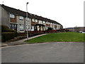
Don Close houses beyond the end of the road, Bettws, Newport
The row of houses extends for about 50 metres beyond the turning circle.
Image: © Jaggery
Taken: 29 Feb 2016
0.00 miles
2
Don Close houses, Bettws, Newport
Viewed from Humber Road.
Image: © Jaggery
Taken: 22 Aug 2018
0.01 miles
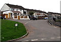
3
Bettws Day Nursery, Monnow Way, Newport
Located between Monnow Way and Don Close. This view is from Monnow Way.
Adjacent to the nursery, beyond the left edge of the photo, is Don Close Nursery School http://www.geograph.org.uk/photo/1574047
UPDATE July 2013
The nursery has closed and is boarded up. http://www.geograph.org.uk/photo/3537146
Image: © Jaggery
Taken: 7 Nov 2009
0.01 miles
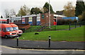
4
Bus stop and shelter alongside bus route 16, Monnow Way, Bettws, Newport
Route 16 is city centre to Bettws via Monnow Way (clockwise) then back to the city centre.
Image: © Jaggery
Taken: 29 Feb 2016
0.02 miles
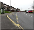
5
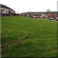
Twin tracks on the grass, Bettws, Newport
Evidence of recent off-roading on the green between Don Close and Monnow Way.
Image: © Jaggery
Taken: 29 Feb 2016
0.03 miles
6
Rooftop solar panels, Monnow Way, Bettws, Newport
Viewed from this bus shelter. http://www.geograph.org.uk/photo/4845032
Image: © Jaggery
Taken: 29 Feb 2016
0.03 miles
7
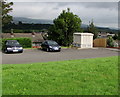
Lambourne Walk electricity substation, Bettws, Newport
Viewed from Monnow Way, the main road through the Bettws Estate. The large cabinet is a Western Power Distribution electricity substation, identifier LAMBOURNE WALK BETTWS S/S 532129
Image: © Jaggery
Taken: 22 Aug 2018
0.03 miles
8
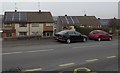
Monnow Way bus stop and shelter near Lambourne Crescent, Bettws, Newport
This stop is on Newport Bus Route 15 (city centre to Bettws via Monnow Way (counterclockwise) then back to the city centre). A nearby stop on the opposite side of the road is part of Route 16 (city centre to Bettws via Monnow Way (clockwise) then back to the city centre).
Image: © Jaggery
Taken: 29 Feb 2016
0.04 miles
9
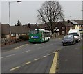
Newport Bus single-decker on Route 15, Bettws, Newport
The bus is at this http://www.geograph.org.uk/photo/4844996 Monnow Way bus stop.
Image: © Jaggery
Taken: 29 Feb 2016
0.04 miles
10
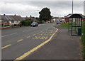
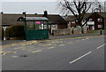
Two bus stops and shelters, Monnow Way, Bettws, Newport
In August 2018 the stop on the right is on Newport Bus Route 16 to and from Friars Walk bus station via Monnow Way (clockwise). The stop behind the car is on Newport Bus Route 15 to and from Friars Walk bus station via Monnow Way (anticlockwise) and is also used by Phil Anslow Coaches on bus route 25 to Cwmbran bus station via Malpas Road and Llantarnam.
Image: © Jaggery
Taken: 22 Aug 2018
0.04 miles