IMAGES TAKEN NEAR TO
Don Close, NEWPORT, NP20 7RT
Introduction
This page details the photographs taken nearby to Don Close, NP20 7RT by members of the Geograph project.
The Geograph project started in 2005 with the aim of publishing, organising and preserving representative images for every square kilometre of Great Britain, Ireland and the Isle of Man.

There are currently over 7.5m images from over14,400 individuals and you can help contribute to the project by visiting https://www.geograph.org.uk
Image Map
Images are licensed for reuse under creativecommons.org/licenses/by-sa/2.0
Notes
- Clicking on the map will re-center to the selected point.
- The higher the marker number, the further away the image location is from the centre of the postcode.
Image Listing (130 Images Found)
Images are licensed for reuse under creativecommons.org/licenses/by-sa/2.0
Image
Details
Distance
1
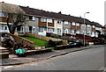
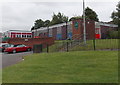
Row of houses, Don Close, Bettws, Newport
The row extends for 35 metres along the south side of Don Close.
Image: © Jaggery
Taken: 29 Feb 2016
0.00 miles
2
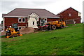
Construction site in Bettws, Newport
In August 2018 houses are being built between Monnow Way and Don Close
on a site previously occupied by two children's nurseries.
Image: © Jaggery
Taken: 22 Aug 2018
0.03 miles
3
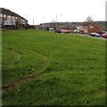
Twin tracks on the grass, Bettws, Newport
Evidence of recent off-roading on the green between Don Close and Monnow Way.
Image: © Jaggery
Taken: 29 Feb 2016
0.03 miles
4
Yeo Close, Bettws, Newport
Looking towards the end of Yeo Close.
Behind the photographer, Yeo Close bends to the north towards Humber Road.
At top left is the path to St David's Church http://www.geograph.org.uk/photo/1572767
Image: © Jaggery
Taken: 7 Nov 2009
0.03 miles
5
Former Bettws Day Nursery, Newport
Viewed from Monnow Way. The boarded-up former nursery has been replaced by nurseries in nearby Millbrook Primary School and Monnow Infants School. The closure was in line with the national policy of attaching nurseries to schools rather than having free-standing council-run nurseries.
Image: © Jaggery
Taken: 2 Jul 2013
0.04 miles
6
Don Close houses, Bettws, Newport
Viewed from Humber Road.
Image: © Jaggery
Taken: 22 Aug 2018
0.04 miles
7
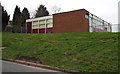
East side of the former Don Close Nursery School, Bettws, Newport
Viewed across Humber Road on February 29th 2016. Don Close Nursery School closed in July 2014.
Children were relocated to either the nursery in Monnow Primary School, or the one in Millbrook Primary School.
Image: © Jaggery
Taken: 29 Feb 2016
0.04 miles
8
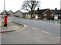
Monnow Way pillarbox opposite Lambourne Crescent, Bettws, Newport
The pillarbox is modern Elizabethan. http://www.geograph.org.uk/photo/4845154
Image: © Jaggery
Taken: 29 Feb 2016
0.04 miles
9
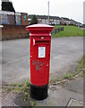
Queen Elizabeth II pillarbox, Monnow Way, Bettws, Newport
Located here. http://www.geograph.org.uk/photo/4845145
Image: © Jaggery
Taken: 29 Feb 2016
0.04 miles
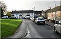
10
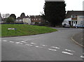
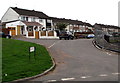
Junction of Humber Road and Don Close, Bettws, Newport
Viewed across Humber Road. Most of the streets in the Bettws area have river names.
Image: © Jaggery
Taken: 29 Feb 2016
0.04 miles