IMAGES TAKEN NEAR TO
Cornbrook Road, NEWPORT, NP20 7EN
Introduction
This page details the photographs taken nearby to Cornbrook Road, NP20 7EN by members of the Geograph project.
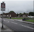
The Geograph project started in 2005 with the aim of publishing, organising and preserving representative images for every square kilometre of Great Britain, Ireland and the Isle of Man.

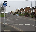
There are currently over 7.5m images from over14,400 individuals and you can help contribute to the project by visiting https://www.geograph.org.uk
Image Map
Images are licensed for reuse under creativecommons.org/licenses/by-sa/2.0
Notes
- Clicking on the map will re-center to the selected point.
- The higher the marker number, the further away the image location is from the centre of the postcode.
Image Listing (144 Images Found)
Images are licensed for reuse under creativecommons.org/licenses/by-sa/2.0
Image
Details
Distance
1
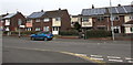
Roof solar panels, Monnow Way, Bettws, Newport
Viewed from the corner of Brookside.
Image: © Jaggery
Taken: 29 Feb 2016
0.04 miles
2
Roof solar panels, Monnow Way, Bettws, Newport
Viewed from Lambourne Way.
Image: © Jaggery
Taken: 29 Feb 2016
0.04 miles
3
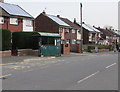
Monnow Way bus stop and shelter, Bettws, Newport
Located 20 metres east of the junction at the northern end
of Lambourne Way, opposite St David Lewis Catholic Church. http://www.geograph.org.uk/photo/1567951
Image: © Jaggery
Taken: 29 Feb 2016
0.05 miles
4
Warning sign - single file traffic, Monnow Way, Bettws, Newport
On the approach to a brief narrowing of the roadway to the width of one lane, a traffic-calming measure.
Image: © Jaggery
Taken: 29 Feb 2016
0.05 miles
5
Bilingual traffic sign alongside Monnow Way, Bettws, Newport
The sign showing Single file traffic and its Welsh equivalent is on the approach to this https://www.geograph.org.uk/photo/5880409 traffic calming measure. The Brookside junction is on the right.
Image: © Jaggery
Taken: 20 Aug 2018
0.05 miles
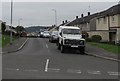
6
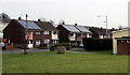
Medlock Crescent
Houses in Medlock Crescent, Bettws.
Image: © Alan Hughes
Taken: 5 Sep 2022
0.05 miles
7
Western end of Cornbrook Road, Bettws, Newport
Looking east along Cornbrook Road from Itchen Close across Itchen Road.
Image: © Jaggery
Taken: 20 Aug 2018
0.05 miles
8
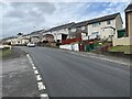
Western end of Medlock Crescent, Bettws, Newport
Looking east across Itchen Road. Medlock Crescent leads to Medlock Close, Cornbrook Road, Plym Walk and Monnow Way, the main road around the Bettws Estate.
Image: © Jaggery
Taken: 21 Aug 2018
0.06 miles
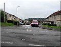
9
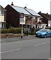
Mini-roundabout sign, Monnow Way, Bettws, Newport
Facing Monnow Way a few metres from the mini-roundabout at the Lambourne Way junction.
Image: © Jaggery
Taken: 29 Feb 2016
0.06 miles
10
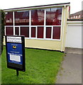
St David Lewis Catholic Church nameboard, Bettws, Newport
At the Monnow Way entrance to this http://www.geograph.org.uk/photo/1567951 church, part of the Roman Catholic Archdiocese of Cardiff.
Image: © Jaggery
Taken: 29 Feb 2016
0.06 miles