IMAGES TAKEN NEAR TO
Frome Walk, NEWPORT, NP20 7BA
Introduction
This page details the photographs taken nearby to Frome Walk, NP20 7BA by members of the Geograph project.
The Geograph project started in 2005 with the aim of publishing, organising and preserving representative images for every square kilometre of Great Britain, Ireland and the Isle of Man.

There are currently over 7.5m images from over14,400 individuals and you can help contribute to the project by visiting https://www.geograph.org.uk
Image Map
Images are licensed for reuse under creativecommons.org/licenses/by-sa/2.0
Notes
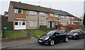
- Clicking on the map will re-center to the selected point.
- The higher the marker number, the further away the image location is from the centre of the postcode.
Image Listing (98 Images Found)
Images are licensed for reuse under creativecommons.org/licenses/by-sa/2.0
Image
Details
Distance
1
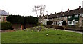
Rock feature, Frome Walk, Bettws, Newport
Viewed at the end of February 2016. I wondered whether this small rocky mound is a rock garden.
Image: © Jaggery
Taken: 29 Feb 2016
0.05 miles
2
BT phonebox, Frome Walk, Bettws, Newport
At the western end of Frome Walk, viewed from Monnow Way.
Image: © Jaggery
Taken: 29 Feb 2016
0.05 miles
3
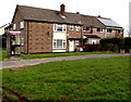
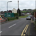
Rear access road to Monnow Walk and Frome Walk, Bettws, Newport
On the east side of Monnow Way, the main road through Bettws.
Image: © Jaggery
Taken: 29 Feb 2016
0.07 miles
4
Damaged Frome Walk name sign, Bettws, Newport
Alongside Monnow Way, viewed on February 29th 2016.
It looks like the damage was caused by a vehicle collision.
Image: © Jaggery
Taken: 29 Feb 2016
0.07 miles
5
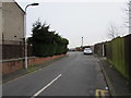
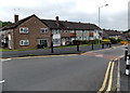
Side road to Monnow Walk, Bettws, Newport
From Monnow Way. A nearby sign pointing this way shows Monnow Walk (59-67).
Image: © Jaggery
Taken: 29 May 2014
0.07 miles
6
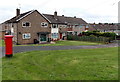
Monnow Way postbox, Bettws, Newport
On the corner of Cherwell Walk.
Image: © Jaggery
Taken: 29 May 2014
0.07 miles
7
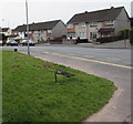
Monnow Way traffic calming near Clist Road, Bettws, Newport
A narrowing of the roadway and a bump are intended to slow down traffic
along the main road through Bettws. Clist Road http://www.geograph.org.uk/photo/4002216 is out of shot on the left.
Image: © Jaggery
Taken: 29 May 2014
0.07 miles
8
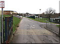
Entrance to Monnow Primary School, Bettws, Newport
From Darent Close.
Image: © Jaggery
Taken: 29 Feb 2016
0.08 miles
9
Houses at the eastern end of Darent Close, Bettws, Newport
The entrance http://www.geograph.org.uk/photo/4923469 to Monnow Primary School is a few metres beyond the right edge of the photo.
Image: © Jaggery
Taken: 29 Feb 2016
0.08 miles
10
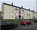
Darent Close flats, Bettws, Newport
3-storey block of flats opposite Darent Road.
Image: © Jaggery
Taken: 29 Feb 2016
0.08 miles