IMAGES TAKEN NEAR TO
Tone Close, NEWPORT, NP20 7AU
Introduction
This page details the photographs taken nearby to Tone Close, NP20 7AU by members of the Geograph project.
The Geograph project started in 2005 with the aim of publishing, organising and preserving representative images for every square kilometre of Great Britain, Ireland and the Isle of Man.

There are currently over 7.5m images from over14,400 individuals and you can help contribute to the project by visiting https://www.geograph.org.uk
Image Map
Images are licensed for reuse under creativecommons.org/licenses/by-sa/2.0
Notes
- Clicking on the map will re-center to the selected point.
- The higher the marker number, the further away the image location is from the centre of the postcode.
Image Listing (185 Images Found)
Images are licensed for reuse under creativecommons.org/licenses/by-sa/2.0
Image
Details
Distance
1
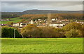
Central Bettws, Newport
A view from Monnow Way (near Lambourne Crescent) across the lower, central part of the Bettws estate. In the far distance is the mounded peak of Twm Barlwm Image .
Image: © Jaggery
Taken: 7 Nov 2009
0.04 miles
2
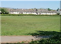
Tone Close houses, Bettws, Newport
Viewed across a recreational field from the edge of a footbridge http://www.geograph.org.uk/photo/2398835 over Bettws Brook.
Image: © Jaggery
Taken: 28 Apr 2011
0.04 miles
3
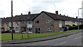
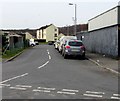
Tone Road, Bettws, Newport
From Tone Close.
Image: © Jaggery
Taken: 29 May 2014
0.07 miles
4
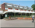
Bettws post office, Newport
Located on the west side of Bettws shopping centre. The post office was formerly in this building http://www.geograph.org.uk/photo/2398796 nearby, now the police station.
Image: © Jaggery
Taken: 28 Apr 2011
0.07 miles
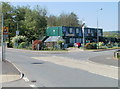
5

Spar, Bettws, Newport
Located in the shopping centre on the west side of Lambourne Way.
Image: © Jaggery
Taken: 28 Apr 2011
0.07 miles
6
Unnamed side road, Bettws, Newport
On the west side of Lambourne Way, at the southern edge of Bettws Shopping Centre.
Several of the parked vehicles are police vehicles. http://www.geograph.org.uk/photo/4847908 Bettws Police Station is nearby. http://www.geograph.org.uk/photo/4848862
Image: © Jaggery
Taken: 29 Feb 2016
0.07 miles
7
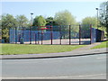
Games court, Lambourne Way, Bettws, Newport
The red and blue enclosed games court is on the east side of Lambourne Way, about 70 metres north of the Wye Crescent junction. The rectangular court is about 35 metres long and 18 metres wide.
Image: © Jaggery
Taken: 28 Apr 2011
0.08 miles
8
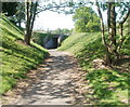
Lambourne Way underpass, Bettws, Newport
A path approaches an underpass beneath Lambourne Way. Viewed from the edge of a games court. http://www.geograph.org.uk/photo/2398681
Image: © Jaggery
Taken: 28 Apr 2011
0.08 miles
9
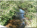
Bettws Brook flows towards Lambourne Way, Newport
Exactly where this small stream is renamed from Bettws Brook to Malpas Brook is unclear from maps, so as this location is in the heart of Bettws, Bettws Brook seems appropriate.
Image: © Jaggery
Taken: 28 Apr 2011
0.08 miles
10
Bettws in Bloom Community Environmental Association, Newport
Premises located on Lambourne Way, at the southern edge of Bettws Centre shopping area.
Bettws in Bloom is a community group that deals with environmental, educational and recreational issues on the Bettws estate.
Image: © Jaggery
Taken: 28 Apr 2011
0.08 miles